
Size of this preview:
800 × 532 pixels. Other resolutions:
320 × 213 pixels |
640 × 426 pixels |
1,024 × 681 pixels |
1,280 × 851 pixels |
2,560 × 1,702 pixels |
6,016 × 4,000 pixels.
Original file (6,016 × 4,000 pixels, file size: 6.5 MB, MIME type: image/jpeg)
| This is a file from the
Wikimedia Commons. Information from its
description page there is shown below. Commons is a freely licensed media file repository. You can help. |
|
This is an image of a place or building that is listed on the
National Register of Historic Places in the
United States of America. Its reference number is
15000079. |
| Camera location |
| View this and other nearby images on: OpenStreetMap |
|
|---|
| Description |
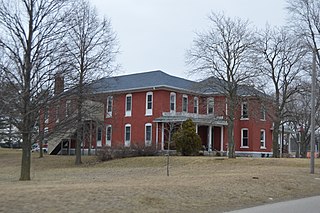
English: Western side and front of the former
Pulaski County Home, located at 700 W60S west of
Winamac in
Monroe Township,
Pulaski County,
Indiana,
United States. Built in 1881, it is listed on the
National Register of Historic Places. |
||
| Date | Taken on 13 March 2015 | ||
| Source | Own work | ||
| Author | Nyttend | ||
| Permission ( Reusing this file) |
|
File history
Click on a date/time to view the file as it appeared at that time.
| Date/Time | Thumbnail | Dimensions | User | Comment | |
|---|---|---|---|---|---|
| current | 15:01, 6 August 2015 |
| 6,016 × 4,000 (6.5 MB) | Nyttend | {{NRHP|15000079}} {{Location|41|2|46|N|86|37|0|W}} {{Information |Description={{en|Western side and front of the former {{w|Pulaski County Home}}, located at 700 W60S west of {{w|Winamac, Indiana|Winamac}} in {{w|Monroe Township, Pulaski County, Indian... |
File usage
The following pages on the English Wikipedia use this file (pages on other projects are not listed):
Global file usage
The following other wikis use this file:
- Usage on www.wikidata.org