
Size of this preview:
800 × 549 pixels. Other resolutions:
320 × 220 pixels |
640 × 439 pixels |
1,024 × 703 pixels |
1,280 × 878 pixels |
2,036 × 1,397 pixels.
Original file (2,036 × 1,397 pixels, file size: 180 KB, MIME type: image/png)
| This is a file from the
Wikimedia Commons. Information from its
description page there is shown below. Commons is a freely licensed media file repository. You can help. |

|
This historical map image could be re-created using
vector graphics as an
SVG file. This has several advantages; see
Commons:Media for cleanup for more information. If an SVG form of this image is available, please upload it and afterwards replace this template with
{{
vector version available|new image name}}
.
It is recommended to name the SVG file “Prima tetrarchia Diocletianus.svg”—then the template Vector version available (or Vva) does not need the new image name parameter. |
Summary
| Description |
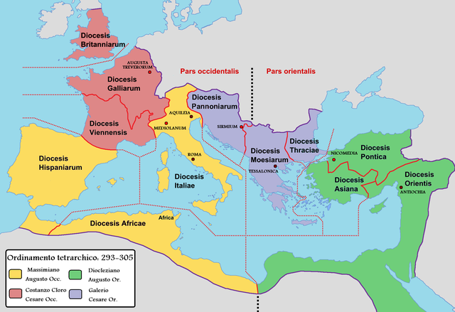
English: Map of the Roman Empire with dioceses created by Diocletien. Italiano: Mappa dell'Impero romano durante la prima tetrarchia di Diocleziano. |
||
| Date | |||
| Source |
|
||
| Author |
|
Licensing
I, the copyright holder of this work, hereby publish it under the following license:
| I, the copyright holder of this work, release this work into the
public domain. This applies worldwide. In some countries this may not be legally possible; if so: I grant anyone the right to use this work for any purpose, without any conditions, unless such conditions are required by law. |
Original upload log
This image is a derivative work of the following images:
-
File:Roman Empire with dioceses in 300 AD.png licensed with PD-self
- 2009-03-10T12:34:18Z Mandrak 2052x1414 (223180 Bytes) Erreurs corrigées.
- 2009-03-03T20:03:56Z Mandrak 2052x1414 (223409 Bytes) {{Information |Description={{en|1=Map of the Roman Empire with dioceses created by Diocletien.}} {{fr|1=Carte de l'Empire romain avec les diocèses créés par l'empereur Dioclétien.}} |Source=travail personnel (own work) |A
Uploaded with derivativeFX
File history
Click on a date/time to view the file as it appeared at that time.
| Date/Time | Thumbnail | Dimensions | User | Comment | |
|---|---|---|---|---|---|
| current | 04:42, 12 February 2022 |
| 2,036 × 1,397 (180 KB) | Lojwe | Frame removed |
| 16:21, 20 May 2011 |
 | 2,069 × 1,434 (206 KB) | Cristiano64 | {{Information |Description={{en|1=Map of the Roman Empire with dioceses created by Diocletien.}} {{it|1=Mappa dell'Impero romano durante la prima tetrarchia di Diocléziano.}} |Source=* File:Roman_Empire_with_dioceses_in_300_AD.png |Date=2011-05-20 1 |
File usage
The following pages on the English Wikipedia use this file (pages on other projects are not listed):
Global file usage
The following other wikis use this file:
- Usage on ast.wikipedia.org
- Usage on cv.wikipedia.org
- Usage on da.wikipedia.org
- Usage on de.wikipedia.org
- Usage on de.wikibooks.org
- Usage on de.wikiversity.org
- Usage on es.wikipedia.org
- Usage on eu.wikipedia.org
- Usage on fr.wikipedia.org
- Usage on hu.wikipedia.org
- Usage on it.wikipedia.org
- Provincia (storia romana)
- Britannia (provincia romana)
- Legione romana
- Diocleziano
- Tetrarchia
- Aquincum
- Tunisia
- Massimiano
- Esercito romano
- Europa meridionale
- Sirmio
- Tarda antichità
- Fortezze legionarie romane
- Storia d'Italia
- Pannonia (provincia romana)
- Tracia (provincia romana)
- Gallia Comata
- Oriente (diocesi)
- Discussioni utente:Panairjdde/Cristiano64
- Ponto (diocesi)
- Africa (diocesi)
- Pannonia (diocesi)
- Tardo impero romano
- Limes africano
- Dislocazione delle legioni romane
- Riforma costantiniana dell'esercito romano
- Asia (diocesi)
- Guerre bagaudiche
- Riforma dioclezianea dell'esercito romano
View more global usage of this file.