
Size of this preview:
800 × 572 pixels. Other resolutions:
320 × 229 pixels |
640 × 458 pixels |
1,024 × 733 pixels |
1,280 × 916 pixels |
2,560 × 1,832 pixels |
6,000 × 4,293 pixels.
Original file (6,000 × 4,293 pixels, file size: 9.63 MB, MIME type: image/jpeg)
| This is a file from the
Wikimedia Commons. Information from its
description page there is shown below. Commons is a freely licensed media file repository. You can help. |
Summary
|
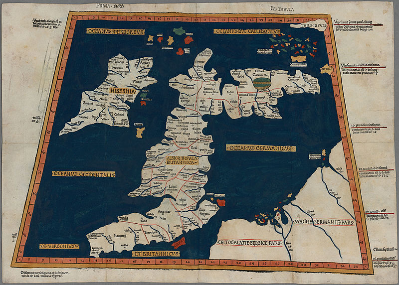
Ptolemy:
Prima Europe Tabula
|
||||||||||||||||||||||||
|---|---|---|---|---|---|---|---|---|---|---|---|---|---|---|---|---|---|---|---|---|---|---|---|---|
| Artist |
|
 | ||||||||||||||||||||||
| Title |
Prima Europe tabula |
|||||||||||||||||||||||
| Part of |
Geography
|
|||||||||||||||||||||||
| Object type |
map
|
|||||||||||||||||||||||
| Description |
One of the earliest surviving copies of Ptolemy's 2nd century map of the British Isles. Originally published in Ptolemy's Geographia. This is the second issue of the 1482 map, also printed at Ulm, which was the first woodcut map of the British Isles and the first to be printed outside Italy. |
|||||||||||||||||||||||
| Date | 1486 | |||||||||||||||||||||||
| Dimensions | height: 350 mm (13.77 in); width: 500 mm (19.68 in) | |||||||||||||||||||||||
| Collection |
|
|||||||||||||||||||||||
| Notes | Scale not given | |||||||||||||||||||||||
| Source/Photographer |
|
|||||||||||||||||||||||
| Permission ( Reusing this file) |
|
|||||||||||||||||||||||


File history
Click on a date/time to view the file as it appeared at that time.
| Date/Time | Thumbnail | Dimensions | User | Comment | |
|---|---|---|---|---|---|
| current | 13:01, 21 October 2015 |
| 6,000 × 4,293 (9.63 MB) | Jason.nlw | User created page with UploadWizard |
File usage
The following pages on the English Wikipedia use this file (pages on other projects are not listed):
Global file usage
The following other wikis use this file:
- Usage on ar.wikipedia.org
- Usage on cy.wikipedia.org
- Usage on da.wikipedia.org
- Usage on de.wikipedia.org
- Usage on el.wikipedia.org
- Usage on es.wikipedia.org
- Usage on et.wikipedia.org
- Usage on hr.wikipedia.org
- Usage on it.wikipedia.org
- Usage on www.wikidata.org
- Usage on zh.wikipedia.org