No higher resolution available.
Postclassicguatemalahighlands.png (600 × 405 pixels, file size: 138 KB, MIME type: image/png)
| This is a file from the
Wikimedia Commons. Information from its
description page there is shown below. Commons is a freely licensed media file repository. You can help. |
Summary
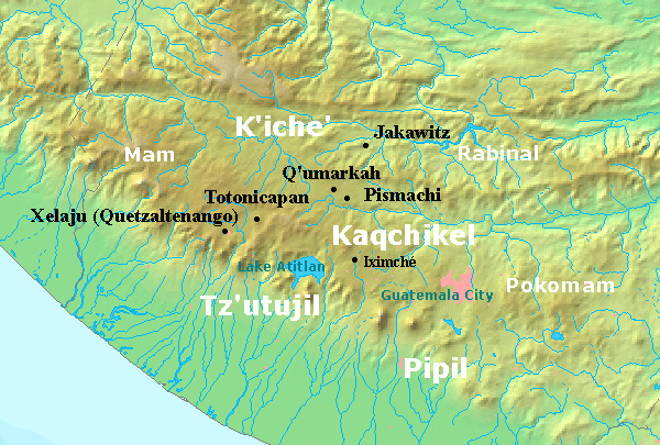
| Description |
English: Map of the southern Guatemala highlands in the postclassic period.
|
||
| Date | |||
| Source | http://en.wikipedia.org/wiki/File:Postclassicguatemalahighlands.png Based upon several maps in Quichean Civilization by Robert M. Carmack; University of California Press 1973. | ||
| Author | Maunus ( talk) | ||
| Permission ( Reusing this file) |
|
File history
Click on a date/time to view the file as it appeared at that time.
| Date/Time | Thumbnail | Dimensions | User | Comment | |
|---|---|---|---|---|---|
| current | 23:21, 22 December 2008 |
| 600 × 405 (138 KB) | Arjuno3 | {{Information |Description={{en|1=Map of southern guatemala in the postclassic period}} |Source=http://en.wikipedia.org/wiki/File:Postclassicguatemalahighlands.png |Author=Maunus |Date=26/02/2008 |Permission= |other_versions= }} <!--{{ImageUpload|full}}- |
File usage
The following pages on the English Wikipedia use this file (pages on other projects are not listed):
Global file usage
The following other wikis use this file:
- Usage on ar.wikipedia.org
- Usage on ca.wikipedia.org
- Usage on es.wikipedia.org
- Usage on fr.wikipedia.org
- Usage on id.wikipedia.org
- Usage on it.wikipedia.org
- Usage on ja.wikipedia.org
- Usage on lt.wikipedia.org
- Usage on nl.wikipedia.org
- Usage on ru.wikipedia.org
- Usage on vi.wikipedia.org
- Usage on www.wikidata.org