
Size of this PNG preview of this SVG file:
512 × 293 pixels. Other resolutions:
320 × 183 pixels |
640 × 366 pixels |
1,024 × 586 pixels |
1,280 × 733 pixels |
2,560 × 1,465 pixels.
Original file (SVG file, nominally 512 × 293 pixels, file size: 185 KB)
| This is a file from the
Wikimedia Commons. Information from its
description page there is shown below. Commons is a freely licensed media file repository. You can help. |
Summary
| Description |
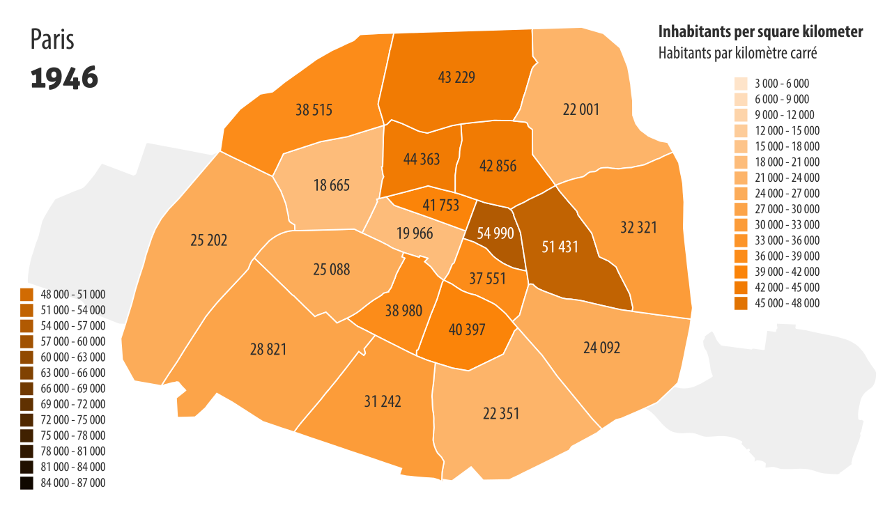
English: Population density map of Paris in 1946.
Sources of data:
Paris Arrondissements: Post 1860 Population & Population Density - Demographia. |
| Date | |
| Source | Own work |
| Author | Paris 16 |
Licensing
I, the copyright holder of this work, hereby publish it under the following license:
This file is licensed under the
Creative Commons
Attribution-Share Alike 4.0 International license.
- You are free:
- to share – to copy, distribute and transmit the work
- to remix – to adapt the work
- Under the following conditions:
- attribution – You must give appropriate credit, provide a link to the license, and indicate if changes were made. You may do so in any reasonable manner, but not in any way that suggests the licensor endorses you or your use.
- share alike – If you remix, transform, or build upon the material, you must distribute your contributions under the same or compatible license as the original.
File history
Click on a date/time to view the file as it appeared at that time.
| Date/Time | Thumbnail | Dimensions | User | Comment | |
|---|---|---|---|---|---|
| current | 18:08, 2 November 2020 |
| 512 × 293 (185 KB) | Paris 16 | |
| 18:07, 2 November 2020 |
 | 512 × 293 (68 KB) | Paris 16 | Uploaded own work with UploadWizard |
File usage
The following pages on the English Wikipedia use this file (pages on other projects are not listed):
Global file usage
The following other wikis use this file:
- Usage on fr.wikipedia.org