
Size of this preview:
600 × 600 pixels. Other resolutions:
240 × 240 pixels |
480 × 480 pixels |
768 × 768 pixels |
1,024 × 1,024 pixels |
2,058 × 2,058 pixels.
Original file (2,058 × 2,058 pixels, file size: 1.7 MB, MIME type: image/jpeg)
| This is a file from the
Wikimedia Commons. Information from its
description page there is shown below. Commons is a freely licensed media file repository. You can help. |
.jpg)
Summary
| Description |
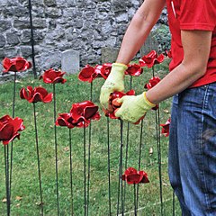
Tower of London Remembers. To mark the centenary anniversary of the First World War the Tower of London is creating an evolving art installation "Blood Swept Lands and Seas of Red". Formed of 888,246 ceramic poppies by artist Paul Cummins, with setting by stage designer Tom Piper, each poppy represents a British military fatality during the war. The installation was officially unveiled on 5 August 2014, one hundred years since the first full day of Britain's involvement in the First World War and will be in place until 11 November 2014. On 24 August I helped to build a just a little more of the installation by constructing and planting a batch of poppies. I believe it is now (as in these photos) about a quarter completed. Each poppy is a life lost - when it is completed maybe it will help to demonstrate the scale of those numbers which we really cannot imagine. |
| Date | |
| Source | Poppy Planting |
| Author | Amanda Slater from Coventry, West Midlands, UK |
| Camera location |
| View this and other nearby images on: OpenStreetMap |
|
|---|
.jpg¶ms=051.507727_N_-000.077033_E_globe:Earth_type:camera_source:Flickr_&language=en)
Licensing
This file is licensed under the
Creative Commons
Attribution-Share Alike 2.0 Generic license.
- You are free:
- to share – to copy, distribute and transmit the work
- to remix – to adapt the work
- Under the following conditions:
- attribution – You must give appropriate credit, provide a link to the license, and indicate if changes were made. You may do so in any reasonable manner, but not in any way that suggests the licensor endorses you or your use.
- share alike – If you remix, transform, or build upon the material, you must distribute your contributions under the same or compatible license as the original.
| This image was originally posted to Flickr by amandabhslater at https://flickr.com/photos/15181848@N02/14845374937. It was reviewed on 1 August 2017 by FlickreviewR and was confirmed to be licensed under the terms of the cc-by-sa-2.0. |
File history
Click on a date/time to view the file as it appeared at that time.
| Date/Time | Thumbnail | Dimensions | User | Comment | |
|---|---|---|---|---|---|
| current | 12:42, 1 August 2017 |
| 2,058 × 2,058 (1.7 MB) | Pigsonthewing | Transferred from Flickr via Flickr2Commons |
File usage
The following pages on the English Wikipedia use this file (pages on other projects are not listed):
.jpg)