
Size of this preview:
800 × 532 pixels. Other resolutions:
320 × 213 pixels |
640 × 426 pixels |
1,024 × 681 pixels |
1,280 × 851 pixels |
2,560 × 1,702 pixels |
6,016 × 4,000 pixels.
Original file (6,016 × 4,000 pixels, file size: 6.39 MB, MIME type: image/jpeg)
| This is a file from the
Wikimedia Commons. Information from its
description page there is shown below. Commons is a freely licensed media file repository. You can help. |
| Camera location |
| View this and other nearby images on: OpenStreetMap |
|
|---|
| Description |
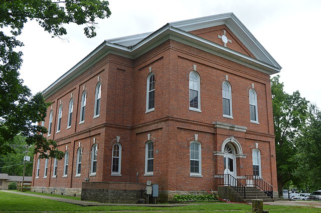
English: Front and eastern side of the
Pope County Courthouse, located at 310 E. Main Street in downtown
Golconda,
Illinois,
United States. Built in 1873, it is part of the
Golconda Historic District, a
historic district that is listed on the
National Register of Historic Places.
|
||
| Date | Taken on 4 June 2016 | ||
| Source | Own work | ||
| Author | Nyttend | ||
| Permission ( Reusing this file) |
|
File history
Click on a date/time to view the file as it appeared at that time.
| Date/Time | Thumbnail | Dimensions | User | Comment | |
|---|---|---|---|---|---|
| current | 14:23, 24 June 2016 |
| 6,016 × 4,000 (6.39 MB) | Nyttend | {{Location|37|22|0|N|88|29|5|W}} {{Information |Description={{en|Front and eastern side of the {{w|Pope County Courthouse (Illinois)|Pope County Courthouse}}, located at 310 E. Main Street in downtown {{w|Golconda, Illinois|Golconda}}, {{w|Illinois}},... |
File usage
The following pages on the English Wikipedia use this file (pages on other projects are not listed):
Global file usage
The following other wikis use this file:
- Usage on ar.wikipedia.org
- Usage on azb.wikipedia.org
- Usage on ceb.wikipedia.org
- Usage on ce.wikipedia.org
- Usage on cy.wikipedia.org
- Usage on de.wikipedia.org
- Usage on es.wikipedia.org
- Usage on fr.wikipedia.org
- Usage on hu.wikipedia.org
- Usage on hy.wikipedia.org
- Usage on ko.wikipedia.org
- Usage on no.wikipedia.org
- Usage on pl.wikipedia.org
- Usage on pt.wikipedia.org
- Usage on ru.wikipedia.org
- Usage on simple.wikipedia.org
- Usage on sl.wikipedia.org
- Usage on sr.wikipedia.org
- Usage on sv.wikipedia.org
- Usage on tr.wikipedia.org
- Usage on tt.wikipedia.org
- Usage on uk.wikipedia.org
- Usage on ur.wikipedia.org
- Usage on www.wikidata.org
- Usage on zh.wikipedia.org