
Size of this PNG preview of this SVG file:
333 × 600 pixels. Other resolutions:
133 × 240 pixels |
266 × 480 pixels |
426 × 768 pixels |
568 × 1,024 pixels |
1,137 × 2,048 pixels |
512 × 922 pixels.
Original file (SVG file, nominally 512 × 922 pixels, file size: 577 KB)
| This is a file from the
Wikimedia Commons. Information from its
description page there is shown below. Commons is a freely licensed media file repository. You can help. |
Summary
| Description | |
| Date | |
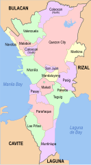
| Source | Map, colors and stroke widths derived from File:Metro manila map (1).png |
| Author | Philtro |
.png)
Licensing
I, the copyright holder of this work, hereby publish it under the following licenses:
This file is licensed under the
Creative Commons
Attribution-Share Alike 3.0 Unported license.
- You are free:
- to share – to copy, distribute and transmit the work
- to remix – to adapt the work
- Under the following conditions:
- attribution – You must give appropriate credit, provide a link to the license, and indicate if changes were made. You may do so in any reasonable manner, but not in any way that suggests the licensor endorses you or your use.
- share alike – If you remix, transform, or build upon the material, you must distribute your contributions under the same or compatible license as the original.

|
Permission is granted to copy, distribute and/or modify this document under the terms of the GNU Free Documentation License, Version 1.2 or any later version published by the Free Software Foundation; with no Invariant Sections, no Front-Cover Texts, and no Back-Cover Texts. A copy of the license is included in the section entitled GNU Free Documentation License. |
You may select the license of your choice.
File history
Click on a date/time to view the file as it appeared at that time.
| Date/Time | Thumbnail | Dimensions | User | Comment | |
|---|---|---|---|---|---|
| current | 08:14, 11 November 2023 |
| 512 × 922 (577 KB) | Hariboneagle927 | update |
| 04:43, 26 November 2021 |
 | 512 × 922 (634 KB) | Hariboneagle927 | Reverted to version as of 14:56, 30 September 2021 (UTC) Reverted to version as of 18:14, 25 September 2021 (UTC) Not sure what is the rationale to upload this version. Previous version allowed the viewers to have a context of how big NCR is compared to the surrounding areas. | |
| 03:51, 26 November 2021 |
 | 656 × 1,280 (305 KB) | Nissan2020 | Reverted to version as of 12:14, 28 March 2021 (UTC) | |
| 14:56, 30 September 2021 |
 | 512 × 922 (634 KB) | Hariboneagle927 | fix text | |
| 14:54, 30 September 2021 |
 | 512 × 922 (467 KB) | Hariboneagle927 | update | |
| 06:12, 4 July 2021 |
 | 700 × 1,260 (517 KB) | Hariboneagle927 | Add Manila South Cemetery exclave | |
| 08:56, 30 March 2021 |
 | 700 × 1,260 (518 KB) | HueMan1 | Reverted to version as of 15:59, 8 May 2011 (UTC) | |
| 12:14, 28 March 2021 |
 | 656 × 1,280 (305 KB) | Teamayuiyui | Update Enhanced Version 2021 | |
| 15:59, 8 May 2011 |
 | 700 × 1,260 (518 KB) | McVahl | {{Information |Description = Political map of Metro Manila, Philippines |Source = Map, colors and stroke widths derived from File:Metro manila map (1).png |Date = 08 May 2011 |Author = Philtro |Permission = |
.png)
File usage
The following pages on the English Wikipedia use this file (pages on other projects are not listed):
- Administrative divisions of Metro Manila
- Index of Metro Manila–related articles
- List of barangays of Metro Manila
- Metropolitan Manila Development Authority
- User:Agos at wolf
- User:Alexius08
- User:Axxand
- User:Axxand/about this user!
- User:Bgh1111
- User:BrokenSphere/Userboxes
- User:BrokenSphere/Userboxes/Metro Manila
- User:Bryan Mayor
- User:Carlo71201
- User:Dan-gee-rous
- User:DarknovaXIV
- User:Democratics
- User:Democratics/userboxes
- User:Derrickflores78
- User:E Wing
- User:Faizza T
- User:Fythring
- User:JParis
- User:KarlcmanRockets
- User:Matthewprc/Userboxes
- User:Mlgc1998
- User:Montelaba
- User:Mx mirav
- User:NaotoATG
- User:Pasawayz
- User:Pickoneword!
- User:Ryomaandres
- User:SilentGanda
- User:Sky Harbor/Userboxes
- User:Stacy twain
- User:ThePasayeño
- Wikipedia talk:WikiProject Userboxes/New Userboxes/Archive 5
Global file usage
The following other wikis use this file:
- Usage on br.wikipedia.org
- Usage on ceb.wikipedia.org
- Usage on de.wikipedia.org
- Usage on eo.wikipedia.org
- Usage on fi.wikipedia.org
- Usage on fr.wikipedia.org
- Usage on hi.wikipedia.org
- Usage on ia.wikipedia.org
- Usage on it.wikipedia.org
- Usage on ja.wikipedia.org
- Usage on ms.wikipedia.org
- Usage on my.wikipedia.org
- Usage on no.wikipedia.org
- Usage on pl.wikipedia.org
- Usage on sv.wikipedia.org
- Usage on tl.wikipedia.org
- Usage on uk.wikipedia.org
- Usage on ur.wikipedia.org
- Usage on war.wikipedia.org
- Usage on www.wikidata.org
- Usage on zh.wikipedia.org