
Size of this PNG preview of this SVG file:
631 × 599 pixels. Other resolutions:
253 × 240 pixels |
505 × 480 pixels |
808 × 768 pixels |
1,078 × 1,024 pixels |
2,156 × 2,048 pixels |
1,200 × 1,140 pixels.
Original file (SVG file, nominally 1,200 × 1,140 pixels, file size: 413 KB)
| This is a file from the
Wikimedia Commons. Information from its
description page there is shown below. Commons is a freely licensed media file repository. You can help. |
.svg)
Summary
| Description |
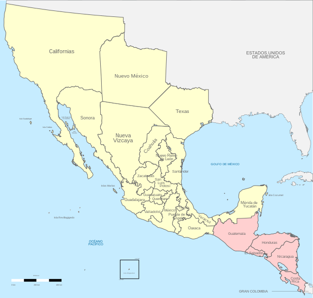
English: Political divisions of 1821 Mexico.
Treaty of Cordoba
Acquisitions (1821–1822) Español: Divisiones políticas de México en 1821.
Page 87 Tratados de Córdoba
Adquisiciones (1821-1822) |
| Date | |
| Source |
Own work Instituto Nacional de Estadística y Geografía (INEGI) |
| Author | Giggette |
| SVG development | |
| Attribution ( required by the license) | © Giggette / Wikimedia Commons / |
| Camera location | | View this and other nearby images on: OpenStreetMap |
|
|---|
.svg¶ms=019.409500_N_-099.130700_E_globe:Earth_type:camera_type:satellite_region:MX_heading:0.00&language=en)
Territorio de mexico, 1821.
Licensing
I, the copyright holder of this work, hereby publish it under the following licenses:
This file is licensed under the
Creative Commons
Attribution-Share Alike 3.0 Unported license.
- You are free:
- to share – to copy, distribute and transmit the work
- to remix – to adapt the work
- Under the following conditions:
- attribution – You must give appropriate credit, provide a link to the license, and indicate if changes were made. You may do so in any reasonable manner, but not in any way that suggests the licensor endorses you or your use.
- share alike – If you remix, transform, or build upon the material, you must distribute your contributions under the same or compatible license as the original.

|
Permission is granted to copy, distribute and/or modify this document under the terms of the GNU Free Documentation License, Version 1.2 or any later version published by the Free Software Foundation; with no Invariant Sections, no Front-Cover Texts, and no Back-Cover Texts. A copy of the license is included in the section entitled GNU Free Documentation License. |
You may select the license of your choice.
File history
Click on a date/time to view the file as it appeared at that time.
| Date/Time | Thumbnail | Dimensions | User | Comment | |
|---|---|---|---|---|---|
| current | 22:18, 18 April 2023 |
| 1,200 × 1,140 (413 KB) | Hohum | Cartographic colours |
| 20:17, 14 December 2017 |
 | 650 × 618 (525 KB) | Milenioscuro | mejor combinación de colores, retiro del gradiente que no corresponde con el del país | |
| 15:36, 29 May 2013 |
 | 650 × 618 (636 KB) | Giggette | tuxpan belongs to puebla | |
| 14:59, 29 May 2013 |
 | 650 × 618 (633 KB) | Giggette | no district of tuxpan | |
| 08:33, 29 May 2013 |
 | 650 × 618 (650 KB) | Giggette | changes according Atlás de la Historia de México, México, UNAM 1990, 133pp González Lamaine | |
| 08:04, 29 May 2013 |
 | 650 × 618 (629 KB) | Giggette | {{Information |Description ={{en|1=c}} |Source ={{own}} |Author = Giggette |Date = |Permission = |other_versions = }} |
File usage
The following pages on the English Wikipedia use this file (pages on other projects are not listed):
Global file usage
The following other wikis use this file:
- Usage on af.wikipedia.org
- Usage on ar.wikipedia.org
- Usage on ast.wikipedia.org
- Usage on azb.wikipedia.org
- Usage on az.wikipedia.org
- Usage on ca.wikipedia.org
- Usage on ckb.wikipedia.org
- Usage on de.wikipedia.org
- Usage on es.wikipedia.org
- Historia de Honduras
- Agustín de Iturbide
- José Cecilio del Valle
- Levantamiento Centroamericano de 1821
- Texas (México)
- Español de Costa Rica
- Anexión de la Capitanía General de Guatemala al Primer Imperio mexicano
- Usuario:Victorcinco523/Texas Mexicana
- Inmigración mexicana en Honduras
- Usuario:Muwatallis II/Taller/002
- Usage on eu.wikipedia.org
- Usage on fr.wikipedia.org
- Usage on hr.wikipedia.org
- Usage on io.wikipedia.org
- Usage on it.wikipedia.org
- Usage on ja.wikipedia.org
- Usage on krc.wikipedia.org
- Usage on la.wikipedia.org
- Usage on mk.wikipedia.org
- Usage on pl.wikipedia.org
- Usage on pt.wikipedia.org
- Usage on ro.wikipedia.org
- Usage on ru.wikipedia.org
- Usage on uk.wikipedia.org
- Usage on ur.wikipedia.org
- Usage on vi.wikipedia.org
- Usage on zh.wikipedia.org
.svg)