
Size of this preview:
741 × 600 pixels. Other resolutions:
297 × 240 pixels |
593 × 480 pixels |
949 × 768 pixels |
1,266 × 1,024 pixels |
2,531 × 2,048 pixels |
3,423 × 2,770 pixels.
Original file (3,423 × 2,770 pixels, file size: 7.13 MB, MIME type: image/jpeg)
| This is a file from the
Wikimedia Commons. Information from its
description page there is shown below. Commons is a freely licensed media file repository. You can help. |
|
| This is a featured picture, which means that members of the community have identified it as one of the finest images on the English Wikipedia, adding significantly to its accompanying article. If you have a different image of similar quality, be sure to upload it using the proper free license tag, add it to a relevant article, and nominate it. |
|
| This image was selected as picture of the day on the English Wikipedia for December 4, 2013. |
Summary
| Camera location |
| View this and other nearby images on: OpenStreetMap |
|
|---|
| Description |
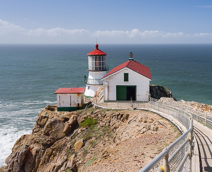
English:
Point Reyes Lighthouse, Marin County, California. Nederlands: De vuurtoren van Point Reyes (Point Reyes Lighthouse) in Marin County (Californië). Deutsch: Leuchtturm Point Reyes, Marin County, Kalifornien. |
|||||||||||||||||||||||
| Date | ||||||||||||||||||||||||
| Source | Own work | |||||||||||||||||||||||
| Author |
|
|||||||||||||||||||||||
| Attribution ( required by the license) | © Frank Schulenburg / | |||||||||||||||||||||||

.jpg)
.jpg¶ms=037.995977_N_-123.022681_E_globe:Earth_type:camera__&language=en)
|
This is an image of a place or building that is listed on the
National Register of Historic Places in the
United States of America. Its reference number is
91001100. |
|
This is a photo of a lighthouse that has been listed by the
United States Lighthouse Society. Its reference number is
616.
|
Assessment
|
.jpg)
Licensing
I, the copyright holder of this work, hereby publish it under the following license:
This file is licensed under the
Creative Commons
Attribution-Share Alike 3.0 Unported license.
- You are free:
- to share – to copy, distribute and transmit the work
- to remix – to adapt the work
- Under the following conditions:
- attribution – You must give appropriate credit, provide a link to the license, and indicate if changes were made. You may do so in any reasonable manner, but not in any way that suggests the licensor endorses you or your use.
- share alike – If you remix, transform, or build upon the material, you must distribute your contributions under the same or compatible license as the original.
File history
Click on a date/time to view the file as it appeared at that time.
| Date/Time | Thumbnail | Dimensions | User | Comment | |
|---|---|---|---|---|---|
| current | 00:02, 2 April 2012 |
| 3,423 × 2,770 (7.13 MB) | Frank Schulenburg |
File usage
The following pages on the English Wikipedia use this file (pages on other projects are not listed):
- Point Reyes National Seashore
- The Fog
- Talk:Point Reyes Lighthouse
- User:Jj98/Random featured picture
- User:Jj98/Random featured picture/4
- User:Mercurywoodrose/SFBA galleries
- User:Spongie555/Archive 3
- Wikipedia:Featured picture candidates/Point Reyes Lighthouse
- Wikipedia:Featured picture candidates/September-2012
- Wikipedia:Featured pictures/Places/Others
- Wikipedia:Featured pictures thumbs/30
- Wikipedia:Main Page history/2013 December 4
- Wikipedia:Picture of the day/December 2013
- Wikipedia:WikiProject Lighthouses/Recognized content
- Wikipedia:Wikipedia Signpost/2012-09-17/Featured content
- Wikipedia:Wikipedia Signpost/Single/2012-09-17
- Template:POTD/2013-12-04
- Portal:San Francisco Bay Area/Selected picture/19
- Portal:San Francisco Bay Area/Selected picture/Archive
Global file usage
The following other wikis use this file:
- Usage on de.wikipedia.org
- Point Reyes National Seashore
- Wikipedia:Exzellente Bilder/Kunst und Kultur
- Wikipedia:Hauptseite/Schon gewusst/Archiv/2013/03
- Wikipedia Diskussion:Hauptseite/Schon gewusst/Diskussionsarchiv/2013/März
- Wikipedia:Hauptseite/Schon gewusst/Zeittafel
- Wikipedia:Hauptseite/Archiv/26. März 2013
- Wikipedia:Kandidaten für exzellente Bilder/Archiv2017/2
- Datei:Point Reyes Lighthouse (April 2012).jpg
- Usage on de.wikivoyage.org
- Usage on en.wikivoyage.org
- Usage on es.wikipedia.org
- Usage on fa.wikipedia.org
- Usage on fr.wikipedia.org
- Usage on it.wikipedia.org
- Usage on ja.wikipedia.org
- Usage on nl.wikipedia.org
- Usage on nl.wikivoyage.org
- Usage on no.wikipedia.org
- Usage on pl.wikipedia.org
- Usage on pt.wikipedia.org
.jpg)
.jpg&oldid=582278279)