
Size of this PNG preview of this SVG file:
800 × 511 pixels. Other resolutions:
320 × 204 pixels |
640 × 409 pixels |
1,024 × 654 pixels |
1,280 × 818 pixels |
2,560 × 1,636 pixels |
3,600 × 2,300 pixels.
Original file (SVG file, nominally 3,600 × 2,300 pixels, file size: 361 KB)
| This is a file from the
Wikimedia Commons. Information from its
description page there is shown below. Commons is a freely licensed media file repository. You can help. |
Summary
| Description |
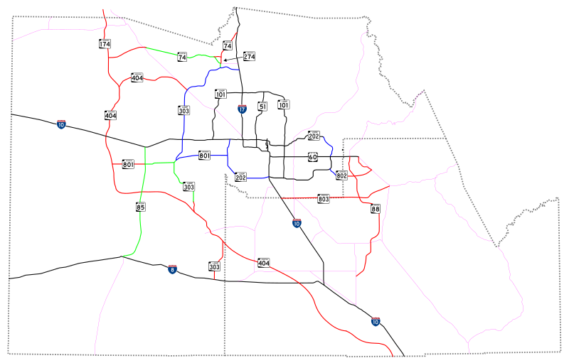
This is a map showing existing, planned and conceptual freeways in the Phoenix Metropolitan area. It is based on planning documents for the cities of Phoenix, Mesa, Peoria, Buckeye, Surprise, Goodyear, Coolidge, Florence and Apache Junction, MAG studies and ADOT information. The routing of unfinished roadways is subject to change, and the numbering of future routes is hypothetical. Black indicates existing freeways, blue indicates new freeway construction funded in the current MAG regional transportation plan (RTP), green indicates future freeway construction with right-of-way preservation funded in the RTP, and red indicates unfunded, conceptual future freeways. Magenta indicates other existing surface highways. |
| Date | 05-08-2008 |
| Source | Own work |
| Author | Arkyan |
Licensing
I, the copyright holder of this work, hereby publish it under the following license:
This file is licensed under the
Creative Commons
Attribution 3.0 Unported license.
- You are free:
- to share – to copy, distribute and transmit the work
- to remix – to adapt the work
- Under the following conditions:
- attribution – You must give appropriate credit, provide a link to the license, and indicate if changes were made. You may do so in any reasonable manner, but not in any way that suggests the licensor endorses you or your use.
File history
Click on a date/time to view the file as it appeared at that time.
| Date/Time | Thumbnail | Dimensions | User | Comment | |
|---|---|---|---|---|---|
| current | 15:48, 8 May 2008 |
| 3,600 × 2,300 (361 KB) | Shereth | {{Information |Description=This is a map showing existing, planned and conceptual freeways in the Phoenix Metropolitan area. It is based on planning documents for the cities of Phoenix, Mesa, Peoria, Buckeye, Surprise, Goodyear, Coolidge, Florence and Ap |
File usage
The following pages on the English Wikipedia use this file (pages on other projects are not listed):