
Size of this preview:
800 × 578 pixels. Other resolutions:
320 × 231 pixels |
640 × 463 pixels |
1,024 × 740 pixels |
1,280 × 925 pixels |
2,560 × 1,851 pixels |
4,011 × 2,900 pixels.
Original file (4,011 × 2,900 pixels, file size: 6.58 MB, MIME type: image/jpeg)
| This is a file from the
Wikimedia Commons. Information from its
description page there is shown below. Commons is a freely licensed media file repository. You can help. |
Summary
|
| Description |
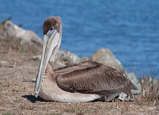
English: Juvenile Brown Pelican (Pelecanus occidentalis) at Bodega Harbor, California, United States. After reporting this beringed bird at the International Bird Rescue Center San Francisco, its Director Emeritus Jay Holcomb sent me this message: “Thanks so much for reporting this bird. It came into our clinic for rehabilitation on July 17, 2012. It was thin, weak and contaminated with fish oil from the fish processing stations. It was released at Ft. Baker under the Golden Gate Bridge on August 17, 2012.” Deutsch: Junger Braunpelikan (Pelecanus occidentalis) bei Bodega Harbor, Kalifornien, Vereinigte Staaten. Nachdem ich die Beobachtung dieses beringten Tieres beim International Bird Rescue Center in San Francisco gemeldet hatte, schickte mir dessen Director Emeritus Jay Holcomb diese Nachricht: „Vielen herzlichen Dank für die Meldung dieses Vogels. Er kam am 17. Juli 2012 zur Rehabilitation in unsere Klinik. Er war dünn, schwach und mit Fischöl von den Fischverarbeitungsanlagen verschmutzt. Wir haben den Vogel am 17. August bei Fort Baker unter der Golden Gate Bridge wieder in die Freiheit entlassen.“ |
|||||||||||||||||||||||
| Date | Taken on 30 September 2012, 12:41:10 | |||||||||||||||||||||||
| Source | Own work | |||||||||||||||||||||||
| Author |
|
|||||||||||||||||||||||
| Attribution ( required by the license) | © Frank Schulenburg / | |||||||||||||||||||||||

| Camera location |
| View this and other nearby images on: OpenStreetMap |
|
|---|
Licensing
Frank Schulenburg, the copyright holder of this work, hereby publishes it under the following license:
This file is licensed under the
Creative Commons
Attribution-Share Alike 3.0 Unported license.
Attribution: Frank Schulenburg
- You are free:
- to share – to copy, distribute and transmit the work
- to remix – to adapt the work
- Under the following conditions:
- attribution – You must give appropriate credit, provide a link to the license, and indicate if changes were made. You may do so in any reasonable manner, but not in any way that suggests the licensor endorses you or your use.
- share alike – If you remix, transform, or build upon the material, you must distribute your contributions under the same or compatible license as the original.
File history
Click on a date/time to view the file as it appeared at that time.
| Date/Time | Thumbnail | Dimensions | User | Comment | |
|---|---|---|---|---|---|
| current | 22:01, 30 September 2012 |
| 4,011 × 2,900 (6.58 MB) | Frank Schulenburg | User created page with UploadWizard |
File usage
The following pages on the English Wikipedia use this file (pages on other projects are not listed):
Global file usage
The following other wikis use this file:
- Usage on de.wikipedia.org
- Usage on el.wikipedia.org
- Usage on no.wikipedia.org
- Usage on pt.wikipedia.org
- Usage on vi.wikipedia.org
- Usage on zh.wikipedia.org