
Size of this PNG preview of this SVG file:
587 × 600 pixels. Other resolutions:
235 × 240 pixels |
470 × 480 pixels |
752 × 768 pixels |
1,002 × 1,024 pixels |
2,004 × 2,048 pixels |
1,552 × 1,586 pixels.
Original file (SVG file, nominally 1,552 × 1,586 pixels, file size: 540 KB)
| This is a file from the
Wikimedia Commons. Information from its
description page there is shown below. Commons is a freely licensed media file repository. You can help. |
Summary
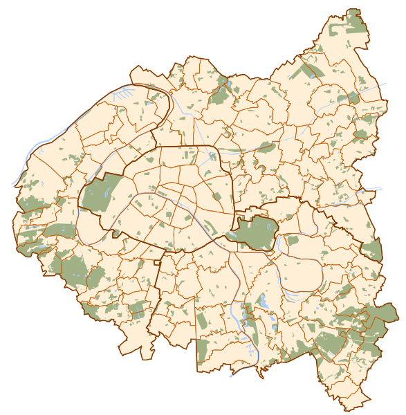
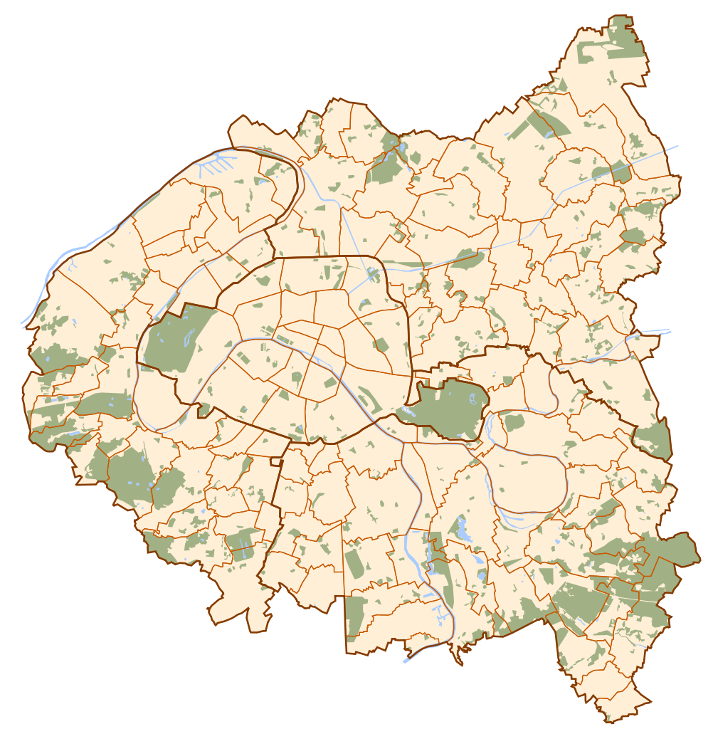
| Description | Map of Paris and its inner ring départements. |
| Date | |
| Source | Own work |
| Author | Metropolitan |
| Other versions | Derivative works of this file: Locator map of Paris.svg |
Licensing
| I, the copyright holder of this work, release this work into the
public domain. This applies worldwide. In some countries this may not be legally possible; if so: I grant anyone the right to use this work for any purpose, without any conditions, unless such conditions are required by law. |
File history
Click on a date/time to view the file as it appeared at that time.
| Date/Time | Thumbnail | Dimensions | User | Comment | |
|---|---|---|---|---|---|
| current | 14:41, 16 March 2007 |
| 1,552 × 1,586 (540 KB) | Metropolitan~commonswiki | {{Information |Description=Map of Paris and its inner ring départements. |Source=Own work |Date=March 16th, 2007 |Author=Metropolitan }} |
File usage
The following pages on the English Wikipedia use this file (pages on other projects are not listed):
- 1900 Summer Olympics
- 2024 Summer Olympics
- Aristide Briand station
- Basilique de Saint-Denis station
- Bobigny–Pablo Picasso station
- Carrefour Pleyel station
- Chalais-Meudon
- Church of Notre-Dame-des-Vertus, Aubervilliers
- Church of Our Lady of the Assumption, Stains
- Church of Saint-Cyr-Sainte-Julitte, Villejuif
- Church of Saint-Julien-de-Brioude, Marolles-en-Brie
- Church of Saint-Médard, Tremblay-en-France
- Church of Saint-Ouen-le-Vieux
- Church of Saint Baudilus, Neuilly-sur-Marne
- Church of St. Nicholas, Saint-Maur-des-Fossés
- Church of St. Peter, Chennevières-sur-Marne
- Church of St. Peter and St. Paul (Montreuil, Seine-Saint-Denis)
- Créteil–L'Échat station
- Créteil–Préfecture station
- Côteaux Beauclair station
- Football at the 1924 Summer Olympics
- Fort d'Aubervilliers station
- Fort d'Ivry
- Fort de Champigny
- Fort de Charenton
- Fort de Châtillon
- Fort de Nogent
- Fort de Romainville
- Fort de Sucy
- Fort de Vaujours
- Fort de Villiers
- Fort de l'Est
- Gabriel Péri station
- Hôtel de la Capitainerie des Chasses
- La Courneuve–8 mai 1945 station
- La Dhuys station
- Lac de Créteil
- Les Agnettes station
- Les Courtilles station
- Mairie d'Aubervilliers station
- Mairie de Clichy station
- Maisons-Alfort–Les Juilliottes station
- Montreuil–Hôpital station
- Moulin de la Tour (Ivry-sur-Seine)
- Pointe du Lac station
- Romainville–Carnot station
- Saint-Denis–Porte de Paris station
- Saint-Denis–Université station
- Suresnes-Longchamp station
- Val-de-Grâce
- Villejuif–Louis Aragon station
- Villejuif–Paul Vaillant-Couturier station
- Île-de-France
- User:SoftFeta/sandbox
- Module:Location map/data/France Paris and inner ring
- Module:Location map/data/France Paris and inner ring/doc
- Module talk:Location map/data/France Paris and inner ring
Global file usage
The following other wikis use this file:
- Usage on ar.wikipedia.org
- Usage on el.wikipedia.org
- Usage on eo.wikipedia.org
- Bagneux (Hauts-de-Seine)
- Saint-Cloud
- Pariza tombejo de Bagneux
- Pariza tombejo de Saint-Ouen
- Ŝablono:Informkesto Pariza metrostacio
- Liberté (pariza metrostacio)
- Ŝablono:Informkesto Pariza metrostacio/dokumentado
- Sup'Biotech
- Mairie d'Ivry (pariza metrostacio)
- Le Kremlin-Bicêtre (pariza metrostacio)
- Mairie d'Issy (pariza metrostacio)
- Villejuif - Louis Aragon (pariza metrostacio)
- Saint-Denis - Porte de Paris (pariza metrostacio)
- La Courneuve - 8 Mai 1945 (pariza metrostacio)
- Gallieni (pariza metrostacio)
- Châtillon - Montrouge (pariza metrostacio)
- Pont de Levallois - Bécon (pariza metrostacio)
- Pont de Sèvres (pariza metrostacio)
- Mairie de Montreuil (pariza metrostacio)
- Mairie des Lilas (pariza metrostacio)
- Mairie de Montrouge (pariza metrostacio)
- Pointe du Lac (pariza metrostacio)
- Bobigny - Pablo Picasso (pariza metrostacio)
- Boulogne - Pont de Saint-Cloud (pariza metrostacio)
- Front Populaire (pariza metrostacio)
- Saint-Denis - Université (pariza metrostacio)
- Les Courtilles (pariza metrostacio)
- Pierre et Marie Curie (pariza metrostacio)
- Villejuif - Léo Lagrange (pariza metrostacio)
- Villejuif - Paul Vaillant-Couturier (pariza metrostacio)
- Pont de Neuilly (pariza metrostacio)
- Corentin Celton (pariza metrostacio)
- Malakoff - Plateau de Vanves (pariza metrostacio)
- Basilique de Saint-Denis (pariza metrostacio)
- Bérault (pariza metrostacio)
- Saint-Mandé (pariza metrostacio)
- Les Sablons (pariza metrostacio)
- Fort d'Aubervilliers (pariza metrostacio)
- Aubervilliers - Pantin - Quatre Chemins (pariza metrostacio)
- Malakoff - Rue Étienne Dolet (pariza metrostacio)
- Garibaldi (pariza metrostacio)
- Les Agnettes (pariza metrostacio)
- Créteil - Préfecture (pariza metrostacio)
- Créteil - Université (pariza metrostacio)
- Créteil - L'Échat (pariza metrostacio)
- Maisons-Alfort - Stade (pariza metrostacio)
- Maisons-Alfort - Les Juilliottes (pariza metrostacio)
View more global usage of this file.