
Size of this PNG preview of this SVG file:
745 × 599 pixels. Other resolutions:
298 × 240 pixels |
597 × 480 pixels |
955 × 768 pixels |
1,273 × 1,024 pixels |
2,545 × 2,048 pixels |
6,977 × 5,614 pixels.
Original file (SVG file, nominally 6,977 × 5,614 pixels, file size: 9.85 MB)
| This is a file from the
Wikimedia Commons. Information from its
description page there is shown below. Commons is a freely licensed media file repository. You can help. |
Summary
| Description |
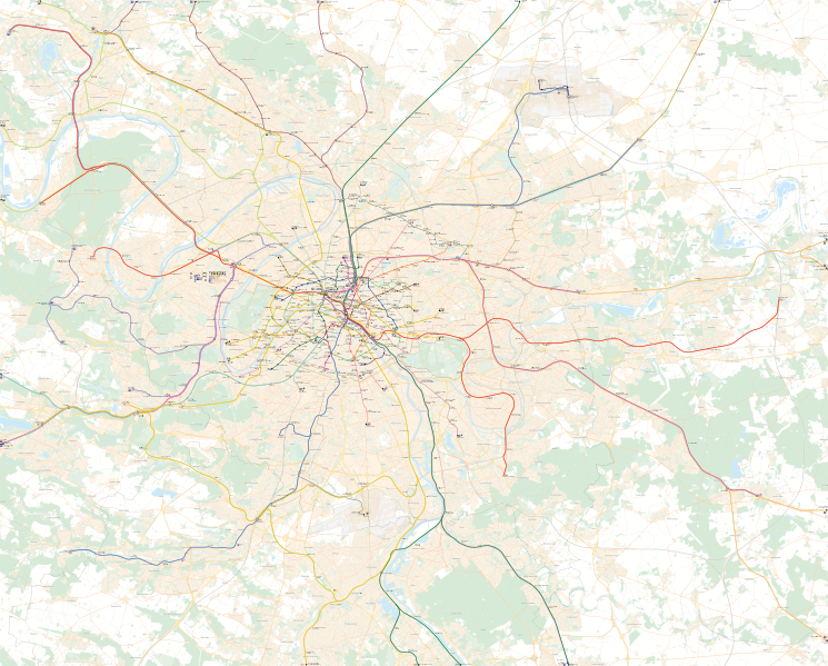
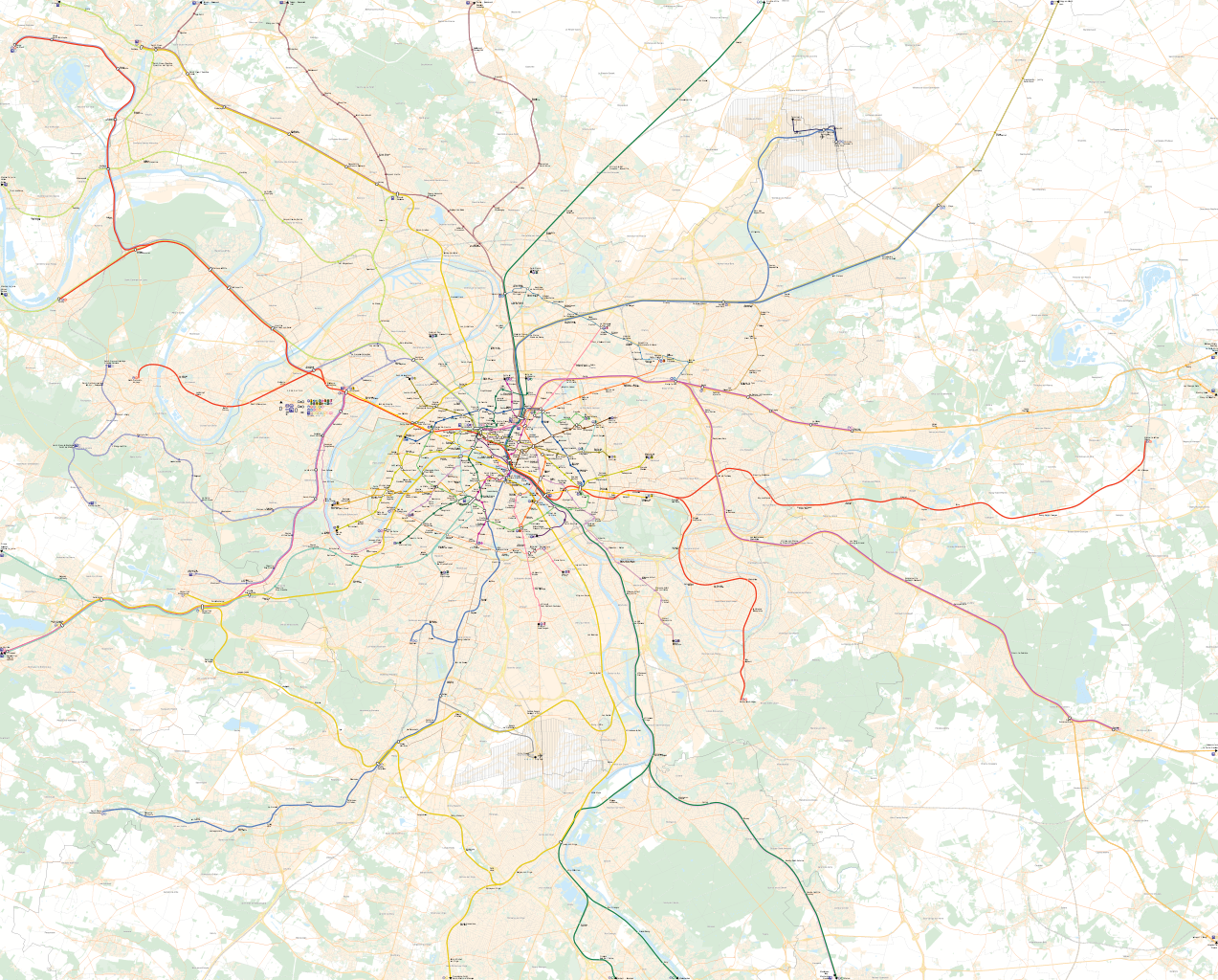
English: Map of Paris rail public transports : Tramway (LRT), Metro, RER, Suburban rails, airport shuttles.
The network graphics are entirely my own work. The background map is a free license work from the
IAURIF.
Français : Plan du réseau ferré des transports en commun parisiens : tramway, metro, RER, transilien, desserte des aéroports.
La création du réseau est une réalisation entièrement personnelle. Le fond de carte est un travail en libre droit d'utilisation de l'
IAURIF. |
| Date | |
| Source | Own work |
| Author | Metropolitan |
| Other versions |
|


Licensing
| I, the copyright holder of this work, release this work into the
public domain. This applies worldwide. In some countries this may not be legally possible; if so: I grant anyone the right to use this work for any purpose, without any conditions, unless such conditions are required by law. |
File history
Click on a date/time to view the file as it appeared at that time.
| Date/Time | Thumbnail | Dimensions | User | Comment | |
|---|---|---|---|---|---|
| current | 18:29, 5 July 2010 |
| 6,977 × 5,614 (9.85 MB) | DieBuche | |
| 21:21, 1 July 2010 |
 | 6,977 × 5,614 (708 KB) | DieBucheBot | Trying to fix SVG using scour | |
| 13:37, 28 September 2008 |
 | 6,977 × 5,614 (1.38 MB) | Metropolitan~commonswiki | {{Information |Description={{en|1=Map of Paris rail public transports : Tramway (LRT), Metro, RER, Suburban rails, airport shuttles. The network graphics are entirely my own work. The background map is a free license work from the [http://www.iau-idf.fr/ |
File usage
No pages on the English Wikipedia use this file (pages on other projects are not listed).
Global file usage
The following other wikis use this file:
- Usage on fa.wikipedia.org
- Usage on fr.wikipedia.org
- Usage on hu.wikipedia.org
- Réseau Express Régional
- Párizsi metró
- 14-es metró (Párizs)
- SNCF
- Paris Gare du Nord
- Paris Gare de l’Est
- Paris Gare de Lyon
- Paris Gare d’Austerlitz
- 1-es metró (Párizs)
- Sablon:Île-de-France közlekedése
- Gare Aéroport Charles-de-Gaulle 1
- Gare Aéroport Charles-de-Gaulle 2 TGV
- Gare d’Ermont - Eaubonne
- Gare d’Essonnes - Robinson
- Gare d’Igny
- Gare d’Issy
- Gare d’Issy-Val de Seine
- Gare d’Ivry-sur-Seine
- Gare d’Orangis - Bois de l’Épine
- Gare d’Orly-Ville
- Gare d’Orry-la-Ville - Coye
- Gare d’Orsay-Ville
- Gare d’Ozoir-la-Ferrière
- Gare d’Yerres
- Gare d’Épinay-sur-Orge
- Gare d’Épinay-sur-Seine
- Gare d’Étampes
- Gare d’Étréchy
- Gare d’Évry-Val-de-Seine
- Gare d’Évry - Courcouronnes
- Gare de Bagneux
- Gare de Ballancourt
- Gare de Bièvres
- Gare de Boigneville
- Gare de Boissise-le-Roi
- Gare de Boissy-Saint-Léger
- Gare de Bondy
- Gare de Bouray
- Gare de Bourg-la-Reine
- Gare de Boutigny
- Gare de Breuillet - Bruyères-le-Châtel
View more global usage of this file.