
Size of this preview:
800 × 202 pixels. Other resolutions:
320 × 81 pixels |
640 × 161 pixels |
1,024 × 258 pixels |
1,280 × 323 pixels |
6,458 × 1,628 pixels.
Original file (6,458 × 1,628 pixels, file size: 2.23 MB, MIME type: image/jpeg)
| This is a file from the
Wikimedia Commons. Information from its
description page there is shown below. Commons is a freely licensed media file repository. You can help. |
Summary
| Description |
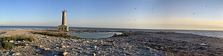
English: Panorama of Mohawk Island, Ontario, in the summer of 2010 during the season which visitors are allowed on. |
| Date | |
| Source | Own work |
| Author | Codell |
| Camera location |
| View this and other nearby images on: OpenStreetMap |
|
|---|
Licensing
| I, the copyright holder of this work, release this work into the
public domain. This applies worldwide. In some countries this may not be legally possible; if so: I grant anyone the right to use this work for any purpose, without any conditions, unless such conditions are required by law. |
File history
Click on a date/time to view the file as it appeared at that time.
| Date/Time | Thumbnail | Dimensions | User | Comment | |
|---|---|---|---|---|---|
| current | 16:13, 8 October 2010 |
| 6,458 × 1,628 (2.23 MB) | Codell | Fixed crop line on right side. |
| 16:08, 8 October 2010 |
| 6,459 × 1,620 (2.23 MB) | Codell | {{Information |Description={{en|1=Panorama of Mohawk Island, Ontario, in the summer of 2010 during the season which visitors are allowed on.}} |Source={{own}} |Author= Codell |Date=2010-08-28 |Permission= |other_versions= }} {{Location|42|5 |
File usage
The following pages on the English Wikipedia use this file (pages on other projects are not listed):
Global file usage
The following other wikis use this file:
- Usage on ca.wikimedia.org
- Usage on fr.wikipedia.org
- Usage on www.wikidata.org