
Size of this preview:
798 × 100 pixels. Other resolutions:
320 × 40 pixels |
640 × 80 pixels |
1,024 × 128 pixels |
1,280 × 160 pixels |
14,921 × 1,870 pixels.
Original file (14,921 × 1,870 pixels, file size: 11.7 MB, MIME type: image/jpeg)
| This is a file from the
Wikimedia Commons. Information from its
description page there is shown below. Commons is a freely licensed media file repository. You can help. |
Summary
| Description |
This image was created with
Hugin. |
| Date | |
| Source | Own work |
| Author | Alchemist-hp ( talk), restitched by Dschwen |
| Camera location |
| View this and other nearby images on: OpenStreetMap |
|
|---|
Licensing
| Copyleft: This work of art is free; you can redistribute it and/or modify it according to terms of the Free Art License. You will find a specimen of this license on the Copyleft Attitude site as well as on other sites. |

|
Permission is granted to copy, distribute and/or modify this document under the terms of the GNU Free Documentation License, Version 1.2 only as published by the Free Software Foundation; with no Invariant Sections, no Front-Cover Texts, and no Back-Cover Texts. A copy of the license is included in the section entitled GNU Free Documentation License. | 1.2 only |
|
|
This file is licensed under the
Creative Commons ‘Attribution-NonCommercial-NonDerivative 3.0 (US)’ Licence: https://creativecommons.org/licenses/by-nc-nd/3.0/ Diese Datei steht unter der Lizenz Creative Commons „Namensnennung-keine kommerzielle Nutzung-keine Bearbeitung 3.0 US“ Lizenz: https://creativecommons.org/licenses/by-nc-nd/3.0/deed.de |
This image has been assessed using the
Quality image guidelines and is considered a
Quality image.
|
File history
Click on a date/time to view the file as it appeared at that time.
| Date/Time | Thumbnail | Dimensions | User | Comment | |
|---|---|---|---|---|---|
| current | 00:17, 7 May 2010 |
| 14,921 × 1,870 (11.7 MB) | Alchemist-hp | restitched |
| 00:07, 2 December 2009 |
| 15,007 × 1,792 (8.59 MB) | Alchemist-hp | size reduced | |
| 23:01, 1 December 2009 |
| 15,007 × 1,792 (13.87 MB) | Alchemist-hp | color cor., 360° cut | |
| 19:54, 1 December 2009 |
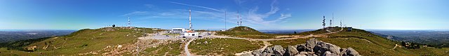
| 15,230 × 1,744 (19.1 MB) | Alchemist-hp | {{Information |Description={{en|1=telecommunication facilities at the mountain Fóia of Algarve, Portugal}} {{de|1=Sendeanlage auf dem höhstem Berg an der Algarve in Portugal: Fóia}} |Source={{own}} |Author= Alchemist-hp |Date={{dat |
File usage
The following pages on the English Wikipedia use this file (pages on other projects are not listed):
Global file usage
The following other wikis use this file:
- Usage on de.wikipedia.org
- Usage on de.wikivoyage.org
- Usage on en.wikivoyage.org
- Usage on es.wikipedia.org
- Usage on fr.wikipedia.org
- Usage on it.wikipedia.org
- Usage on lt.wikipedia.org
- Usage on nl.wikipedia.org
- Usage on oc.wikipedia.org
- Usage on pt.wikipedia.org
- Usage on www.wikidata.org