
Size of this preview:
400 × 600 pixels. Other resolutions:
160 × 240 pixels |
320 × 480 pixels |
512 × 768 pixels |
683 × 1,024 pixels |
1,365 × 2,048 pixels |
4,049 × 6,073 pixels.
Original file (4,049 × 6,073 pixels, file size: 26.33 MB, MIME type: image/jpeg)
| This is a file from the
Wikimedia Commons. Information from its
description page there is shown below. Commons is a freely licensed media file repository. You can help. |
Summary
| Description |
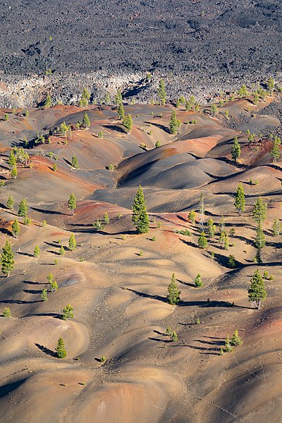
English: Painted Dunes and Fantastic Lava Beds, Lassen Volcanic National Park, as seen from the edge of Cinder Cone’s crater. Painted Dunes consist of layers of oxidized volcanic ash which became so vividly colorful because the ash fell on a bed of lava flows while still hot. Cinder Cone, the Fantastic Lava Beds, and Painted Dunes were formed during two eruptions that occurred in the 1650s. |
|||||||||||||||||||||||
| Date | Taken on 21 June 2020, 18:29:43 | |||||||||||||||||||||||
| Source | Own work | |||||||||||||||||||||||
| Author |
|
|||||||||||||||||||||||
| Attribution ( required by the license) | © Frank Schulenburg / | |||||||||||||||||||||||

.jpg)
| Camera location |
| View this and other nearby images on: OpenStreetMap |
|
|---|
.jpg¶ms=040.546473_N_-121.318932_E_globe:Earth_type:camera__&language=en)
|
.jpg)
Licensing
I, the copyright holder of this work, hereby publish it under the following license:
This file is licensed under the
Creative Commons
Attribution-Share Alike 4.0 International license.
- You are free:
- to share – to copy, distribute and transmit the work
- to remix – to adapt the work
- Under the following conditions:
- attribution – You must give appropriate credit, provide a link to the license, and indicate if changes were made. You may do so in any reasonable manner, but not in any way that suggests the licensor endorses you or your use.
- share alike – If you remix, transform, or build upon the material, you must distribute your contributions under the same or compatible license as the original.
This image has been assessed using the
Quality image guidelines and is considered a
Quality image.
|
File history
Click on a date/time to view the file as it appeared at that time.
| Date/Time | Thumbnail | Dimensions | User | Comment | |
|---|---|---|---|---|---|
| current | 13:40, 23 June 2020 |
| 4,049 × 6,073 (26.33 MB) | Frank Schulenburg | Uploaded own work with UploadWizard |
File usage
The following pages on the English Wikipedia use this file (pages on other projects are not listed):
Global file usage
The following other wikis use this file:
- Usage on ban.wikipedia.org
- Usage on fr.wikipedia.org
- Usage on it.wikipedia.org
- Usage on uk.wikipedia.org
.jpg)