
Size of this preview:
800 × 600 pixels. Other resolutions:
320 × 240 pixels |
640 × 480 pixels |
1,024 × 768 pixels |
1,280 × 960 pixels |
1,446 × 1,084 pixels.
Original file (1,446 × 1,084 pixels, file size: 388 KB, MIME type: image/jpeg)
| This is a file from the
Wikimedia Commons. Information from its
description page there is shown below. Commons is a freely licensed media file repository. You can help. |
Summary
| Description |
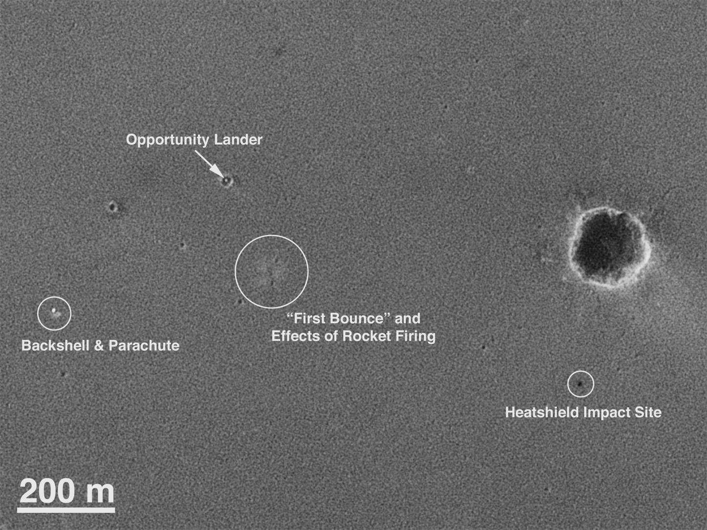
English: This map of the Mars Exploration Rover
Opportunity's new neighborhood at
Meridiani Planum, Mars shows remnants of the rover's landing, including its lander; backshell and parachute; first bounce mark; and the site where its heat shield hit the surface (see inset for exact locations). The image was taken by a camera onboard the
Mars Global Surveyor orbiter.
Deutsch: Diese Aufnahme der Landestelle des NASA-
Rovers
Opportunity der NASA zeigt die Aufschlagspunkte des Landemoduls und des Fallschirms, von denen sich das Landeraumschiff kurz vor dem Aufschlag trennte. Zu sehen ist außerdem der schon früher abgetrennte Hitzeschild. Daraufhin hüpfte das Landeraumschiff mehrmals mit Hilfe seiner Airbags über den Marsboden, bis es in einem kleinen Krater (oben links) zum Stehen kam. Der Krater, der später den Namen Eagle Crater bekam, hat etwa 30m Durchmesser und ist etwa 5m tief. Die Aufnahme wurde von der NASA-
Sonde
Mars Global Surveyor aus dem
Mars-
Orbit gemacht. |
| Date | |
| Source | http://photojournal.jpl.nasa.gov/catalog/PIA05229,OrigCaption ( image link) |
| Author | NASA/JPL/Malin Space Science Systems |
This image or video was catalogued by Jet Propulsion Laboratory of the United States
National Aeronautics and Space Administration (NASA) under Photo ID:
PIA05229. This tag does not indicate the copyright status of the attached work. A normal copyright tag is still required. See Commons:Licensing. Other languages:
|
Licensing
| This file is in the public domain in the United States because it was solely created by NASA. NASA copyright policy states that "NASA material is not protected by copyright unless noted". (See Template:PD-USGov, NASA copyright policy page or JPL Image Use Policy.) | ||
 |
Warnings:
|
Original upload log
The original description page was
here. All following user names refer to en.wikipedia.
- 2004-02-13 21:16 Sennheiser 1446×1084× (397267 bytes)
File history
Click on a date/time to view the file as it appeared at that time.
| Date/Time | Thumbnail | Dimensions | User | Comment | |
|---|---|---|---|---|---|
| current | 22:43, 28 May 2009 |
| 1,446 × 1,084 (388 KB) | File Upload Bot (Magnus Manske) | {{BotMoveToCommons|en.wikipedia|year={{subst:CURRENTYEAR}}|month={{subst:CURRENTMONTHNAME}}|day={{subst:CURRENTDAY}}}} {{Information |Description={{en| en:Category:Images of Mars}} |Source=Transferred from [http://en.wikipedia.org en.wikipedia]; tra |
File usage
The following pages on the English Wikipedia use this file (pages on other projects are not listed):
Global file usage
The following other wikis use this file:
- Usage on ar.wikipedia.org
- Usage on de.wikipedia.org
- Usage on fr.wikipedia.org
- Usage on he.wikipedia.org
- Usage on it.wikipedia.org
- Usage on ko.wikipedia.org
- Usage on pt.wikipedia.org
- Usage on ru.wikipedia.org
- Usage on sh.wikipedia.org
- Usage on sr.wikipedia.org
- Usage on uk.wikipedia.org
- Usage on zh.wikipedia.org