Size of this preview:
798 × 133 pixels. Other resolutions:
320 × 53 pixels |
640 × 107 pixels |
4,201 × 701 pixels.
Original file (4,201 × 701 pixels, file size: 817 KB, MIME type: image/jpeg)
| This is a file from the
Wikimedia Commons. Information from its
description page there is shown below. Commons is a freely licensed media file repository. You can help. |
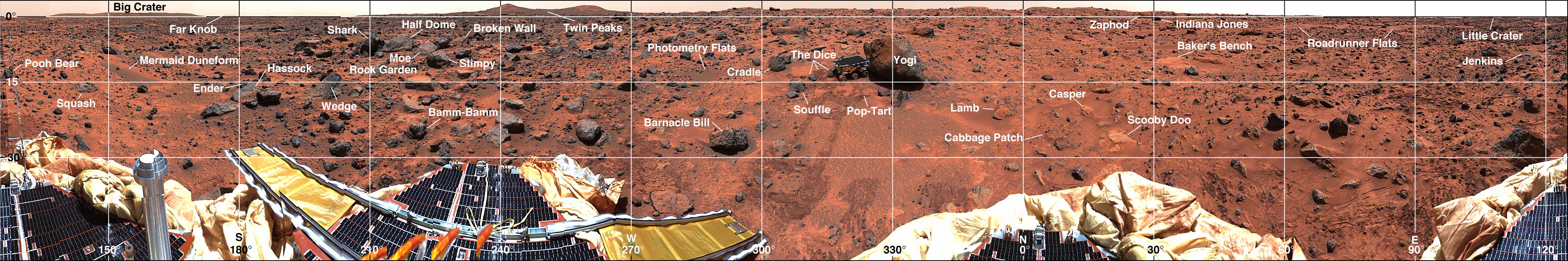
| Description | Mars-local-level (LL frame) coordinate map of rocks counted at the Mars Pathfinder landing site. Positions, apparent diameters (D), and heights (H) were measured to the nearest centimeter in the Mars map virtual reality environment constructed from the "Monster Pan" |
| Source | https://photojournal.jpl.nasa.gov/catalog/PIA01153 |
| Author | NASA |
| Permission ( Reusing this file) |
Original work of NASA - public domain |
| Other versions | http://photojournal.jpl.nasa.gov/catalog/PIA01153 |
| This file is in the public domain in the United States because it was solely created by NASA. NASA copyright policy states that "NASA material is not protected by copyright unless noted". (See Template:PD-USGov, NASA copyright policy page or JPL Image Use Policy.) | ||
 |
Warnings:
|
File history
Click on a date/time to view the file as it appeared at that time.
| Date/Time | Thumbnail | Dimensions | User | Comment | |
|---|---|---|---|---|---|
| current | 18:33, 27 May 2007 |
| 4,201 × 701 (817 KB) | Clh288~commonswiki | {{Information |Description= Mars-local-level (LL frame) coordinate map of rocks counted at the Mars Pathfinder landing site. Positions, apparent diameters (D), and heights (H) were measured to the nearest centimeter in the Mars map virtual reality envi |
File usage
The following pages on the English Wikipedia use this file (pages on other projects are not listed):
Global file usage
The following other wikis use this file:
- Usage on be.wikipedia.org
- Usage on bg.wikipedia.org
- Usage on ru.wikipedia.org
- Usage on uk.wikipedia.org
- Usage on zh.wikipedia.org