
Size of this preview:
601 × 599 pixels. Other resolutions:
241 × 240 pixels |
629 × 627 pixels.
Original file (629 × 627 pixels, file size: 708 KB, MIME type: image/png)
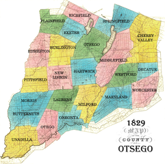
1829 map of Otsego County, New York.
| This file is in the
public domain because its copyright has expired in the United States and those countries with a copyright term of no more than the life of the author plus 100 years.
|
 | This file is a candidate to be copied to
Wikimedia Commons.
Any user may perform this transfer; refer to Wikipedia:Moving files to Commons for details. If this file has problems with attribution, copyright, or is otherwise ineligible for Commons, then remove this tag and DO NOT transfer it; repeat violators may be blocked from editing. Other Instructions
| ||
| |||
File history
Click on a date/time to view the file as it appeared at that time.
| Date/Time | Thumbnail | Dimensions | User | Comment | |
|---|---|---|---|---|---|
| current | 03:38, 24 April 2005 |
| 629 × 627 (708 KB) | Nonenmac ( talk | contribs) | ''' 1829''' map of Otsego County, New York. {{pd}} |
| 03:27, 24 April 2005 |
 | 629 × 627 (708 KB) | Nonenmac ( talk | contribs) | 1829 map of Otsego County, New York. {{pd}} |
You cannot overwrite this file.
File usage
The following pages on the English Wikipedia use this file (pages on other projects are not listed):