
Size of this PNG preview of this SVG file:
800 × 587 pixels. Other resolutions:
320 × 235 pixels |
640 × 469 pixels |
1,024 × 751 pixels |
1,280 × 939 pixels |
2,560 × 1,877 pixels |
1,500 × 1,100 pixels.
Original file (SVG file, nominally 1,500 × 1,100 pixels, file size: 28 KB)
| This is a file from the
Wikimedia Commons. Information from its
description page there is shown below. Commons is a freely licensed media file repository. You can help. |
_-_Towns_and_Villages.svg)
Summary
| Description |
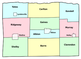
English: Map of
Orleans County, New York, showing its constituent towns and villages. Labels in English. |
| Date | |
| Source | Own work by uploader, based on public domain USGS topographic maps |
| Author | LtPowers |
| Other versions | Image:Orleans County (New York) outline.jpg |
_outline.jpg&action=edit&redlink=1)
This W3C-unspecified
vector image was created with
Inkscape .
Licensing
I, the copyright holder of this work, hereby publish it under the following license:
This file is licensed under the
Creative Commons
Attribution-Share Alike 3.0 Unported license.
- You are free:
- to share – to copy, distribute and transmit the work
- to remix – to adapt the work
- Under the following conditions:
- attribution – You must give appropriate credit, provide a link to the license, and indicate if changes were made. You may do so in any reasonable manner, but not in any way that suggests the licensor endorses you or your use.
- share alike – If you remix, transform, or build upon the material, you must distribute your contributions under the same or compatible license as the original.
File history
Click on a date/time to view the file as it appeared at that time.
| Date/Time | Thumbnail | Dimensions | User | Comment | |
|---|---|---|---|---|---|
| current | 21:46, 11 November 2008 |
| 1,500 × 1,100 (28 KB) | LtPowers | change village labels to condensed and increase point size accordingly |
| 21:38, 11 November 2008 |
 | 1,500 × 1,100 (28 KB) | LtPowers | reduce lower margin | |
| 21:27, 11 November 2008 |
 | 1,500 × 1,500 (28 KB) | LtPowers | {{Information |Description={{en|1=Map of Orleans County, New York, showing its constituent towns and villages. Labels in English.}} |Source=Own work by uploader, based on public domain USGS topographic maps |Author=[[User:L |
File usage
The following pages on the English Wikipedia use this file (pages on other projects are not listed):
- Barre Center, New York
- Childs, New York
- East Gaines, New York
- Hulberton, New York
- Kent, Orleans County, New York
- Knowlesville, New York
- Lakeside Beach State Park
- Millers, New York
- Millville, New York
- Oak Orchard, New York
- Oak Orchard State Marine Park
- Orleans County, New York
- Sawyer, Orleans County, New York
- Waterport, New York
- Template:OrleansCountyNY-geo-stub
Global file usage
The following other wikis use this file:
- Usage on es.wikipedia.org
- Usage on fr.wikipedia.org
- Usage on ja.wikipedia.org
- Usage on nl.wikipedia.org
- Usage on www.wikidata.org
_-_Towns_and_Villages.svg)