
Size of this preview:
706 × 600 pixels. Other resolutions:
283 × 240 pixels |
565 × 480 pixels |
719 × 611 pixels.
Original file (719 × 611 pixels, file size: 246 KB, MIME type: image/jpeg)
| This is a file from the
Wikimedia Commons. Information from its
description page there is shown below. Commons is a freely licensed media file repository. You can help. |

|
This map image could be re-created using
vector graphics as an
SVG file. This has several advantages; see
Commons:Media for cleanup for more information. If an SVG form of this image is available, please upload it and afterwards replace this template with
{{
vector version available|new image name}}
.
It is recommended to name the SVG file “Orinoco USGS.svg”—then the template Vector version available (or Vva) does not need the new image name parameter. |


Summary
| Description |
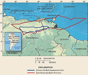
English: Map of Orinoco tar sands assessment unit by USGS |
| Date | |
| Source | http://pubs.usgs.gov/fs/2009/3028/pdf/FS09-3028.pdf |
| Author | USGS |
Licensing
This image is in the
public domain in the United States because it only contains materials that originally came from the
United States Geological Survey, an agency of the
United States Department of the Interior. For more information, see
the official USGS copyright policy.
|
File history
Click on a date/time to view the file as it appeared at that time.
| Date/Time | Thumbnail | Dimensions | User | Comment | |
|---|---|---|---|---|---|
| current | 07:57, 24 January 2010 |
| 719 × 611 (246 KB) | Environnement2100 | {{Information |Description={{en|1=Map of Orinoco tar sands assessment unit by USGS}} |Source=http://pubs.usgs.gov/fs/2009/3028/pdf/FS09-3028.pdf |Author=USGS |Date=October 2009 |Permission= |other_versions= }} Category:Venezuela [[Category:Petroleum] |
File usage
The following pages on the English Wikipedia use this file (pages on other projects are not listed):
Global file usage
The following other wikis use this file:
- Usage on ar.wikipedia.org
- Usage on de.wikipedia.org
- Usage on es.wikipedia.org
- Usage on fa.wikipedia.org
- Usage on fr.wikipedia.org
- Usage on he.wikipedia.org
- Usage on ja.wikipedia.org
- Usage on lt.wikipedia.org
- Usage on nn.wikipedia.org
- Usage on ru.wikipedia.org
- Usage on ta.wikipedia.org
- Usage on vi.wikipedia.org
- Usage on www.wikidata.org