
Size of this preview:
385 × 599 pixels. Other resolutions:
154 × 240 pixels |
308 × 480 pixels |
895 × 1,392 pixels.
Original file (895 × 1,392 pixels, file size: 3.03 MB, MIME type: image/gif, looped, 5 frames, 10 s)
| This is a file from the
Wikimedia Commons. Information from its
description page there is shown below. Commons is a freely licensed media file repository. You can help. |
Summary
| Description |
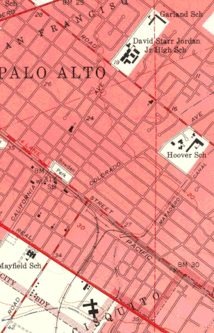
English: Animated GIF of USGS maps of 1953, 1961, 1969, 1974, and 2015, showing the conversion of Oregon Avenue to Oregon Expressway in Palo Alto, California, and its interchange with Alma Street and connection to Page Mill Road. In 1953, Oregon Avenue had a T intersection with Alma Street, while Page Mill Road and California Avenue had level crossings across the Southern Pacific railroad tracks. By 1961, the dog-leg connection between Page Mill Road and Oregon Avenue had been made, but Oregon was still a narrow residential street, which connected to US-101 so it became a very busy route to Stanford and the Stanford Industrial Park. By 1969, the Oregon Expressway had replaced about 90 homes on the south side of Oregon Avenue. By 1974, more ramps were added to the Alma Street interchange. At some point, by 2015, the railroad tracks behind the Sutter Packing Company cannery / Maximart / Fry's building were gone; this was the track that connected the Southern Pacific route that ran along what became Foothill Expressway. |
| Date | |
| Source | Own work |
| Author | Dicklyon |
Licensing
I, the copyright holder of this work, hereby publish it under the following license:
This file is licensed under the
Creative Commons
Attribution-Share Alike 4.0 International license.
- You are free:
- to share – to copy, distribute and transmit the work
- to remix – to adapt the work
- Under the following conditions:
- attribution – You must give appropriate credit, provide a link to the license, and indicate if changes were made. You may do so in any reasonable manner, but not in any way that suggests the licensor endorses you or your use.
- share alike – If you remix, transform, or build upon the material, you must distribute your contributions under the same or compatible license as the original.
File history
Click on a date/time to view the file as it appeared at that time.
| Date/Time | Thumbnail | Dimensions | User | Comment | |
|---|---|---|---|---|---|
| current | 03:49, 29 May 2022 |
| 895 × 1,392 (3.03 MB) | Dicklyon | Uploaded own work with UploadWizard |
File usage
The following pages on the English Wikipedia use this file (pages on other projects are not listed):