Size of this preview:
685 × 599 pixels. Other resolutions:
274 × 240 pixels |
549 × 480 pixels |
878 × 768 pixels |
1,170 × 1,024 pixels |
2,341 × 2,048 pixels |
3,200 × 2,800 pixels.
Original file (3,200 × 2,800 pixels, file size: 1.35 MB, MIME type: image/gif)
| This is a file from the
Wikimedia Commons. Information from its
description page there is shown below. Commons is a freely licensed media file repository. You can help. |

|
This locator map image could be re-created using
vector graphics as an
SVG file. This has several advantages; see
Commons:Media for cleanup for more information. If an SVG form of this image is available, please upload it and afterwards replace this template with
{{
vector version available|new image name}}
.
It is recommended to name the SVG file “OrangeCountyCA Map.svg”—then the template Vector version available (or Vva) does not need the new image name parameter. |
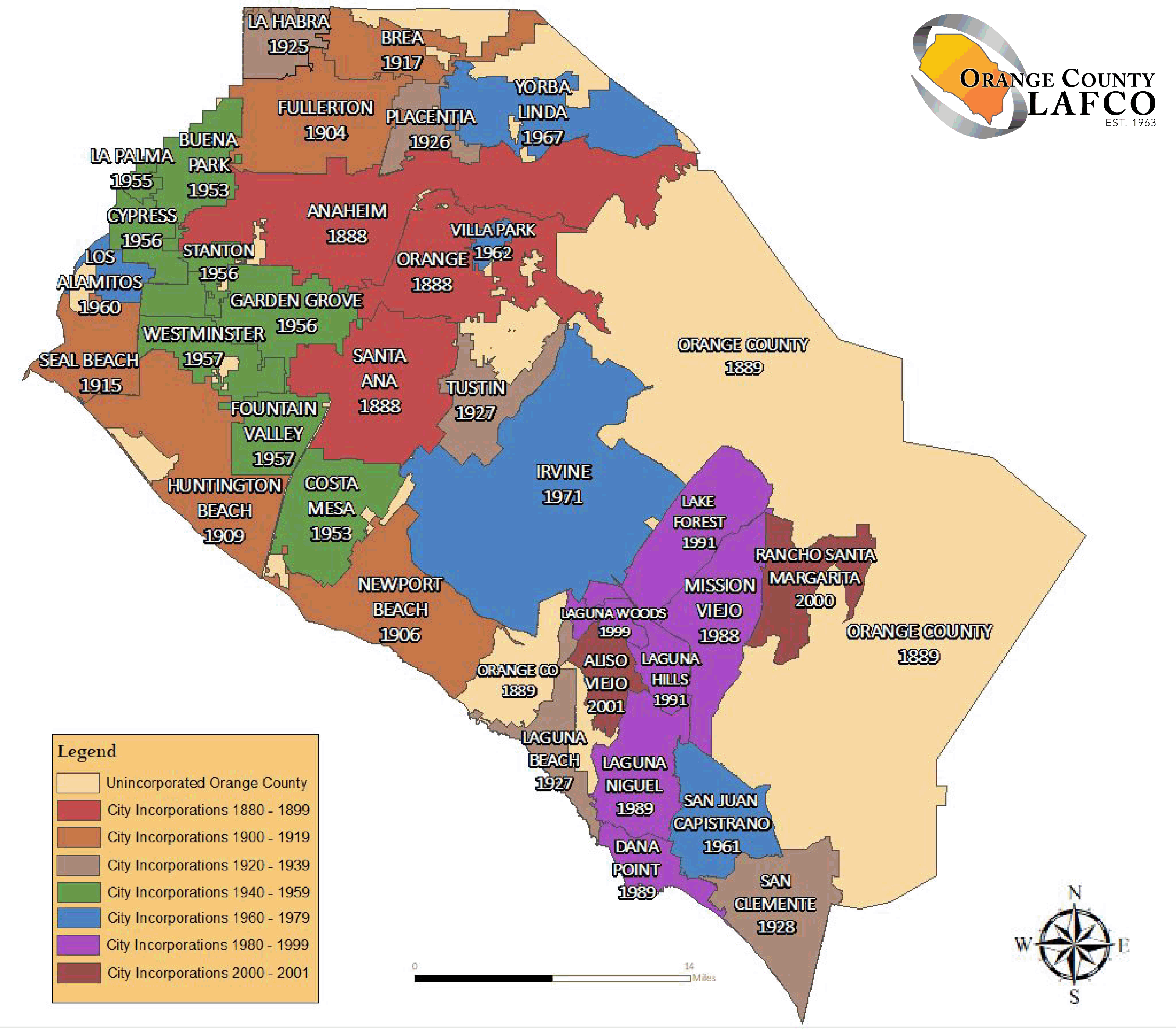
English: The
en:Orange County LAFCO map of
Category:Maps of Orange County with its city's boundaries.
Español: Mapa de las fronteras de las ciudades de Condado de Orange.
Français : Carte des frontières des villes du Comté d'Orange.
Source : import from English Wikipedia. http://en.wikipedia.org/wiki/Image:OrangeCountyCA_Map.gif - Author : MarsRover - public domain
| This work has been released into the
public domain by its author,
MarsRover at
English Wikipedia. This applies worldwide. In some countries this may not be legally possible; if so: MarsRover grants anyone the right to use this work for any purpose, without any conditions, unless such conditions are required by law. |
File history
Click on a date/time to view the file as it appeared at that time.
| Date/Time | Thumbnail | Dimensions | User | Comment | |
|---|---|---|---|---|---|
| current | 03:36, 12 September 2019 |
| 3,200 × 2,800 (1.35 MB) | Fluffy89502 | newer map per https://oclafco.org/index.php/sphere-of-influence-maps/ |
| 01:55, 30 July 2008 |
 | 694 × 557 (29 KB) | MarsRover | {{Information |Description= |Source= |Date= |Author= |Permission= |other_versions= }} | |
| 15:35, 1 October 2006 |
 | 694 × 557 (29 KB) | Laurent Nguyen | Orange County city boundary map. Carte des frontières des villes du Comté d'Orange. Source : import from English Wikipedia. http://en.wikipedia.org/wiki/Image:OrangeCountyCA_Map.gif - Author : MarsRover - public domain |
File usage
The following pages on the English Wikipedia use this file (pages on other projects are not listed):
Global file usage
The following other wikis use this file:
- Usage on af.wikipedia.org
- Usage on cs.wikipedia.org
- Usage on de.wikipedia.org
- Usage on eo.wikipedia.org
- Usage on es.wikipedia.org
- Usage on fa.wikipedia.org
- Usage on fr.wikipedia.org
- Usage on it.wikipedia.org
- Usage on ja.wikipedia.org
- Usage on ml.wikipedia.org
- Usage on ms.wikipedia.org
- Usage on new.wikipedia.org
- Usage on pt.wikipedia.org
- Usage on ro.wikipedia.org
- Usage on ru.wikipedia.org
- Usage on sco.wikipedia.org
- Usage on sv.wikipedia.org
- Usage on tl.wikipedia.org
- Usage on ur.wikipedia.org
- Usage on vi.wikipedia.org
- Usage on zh.wikipedia.org