
Size of this preview:
800 × 543 pixels. Other resolutions:
320 × 217 pixels |
640 × 435 pixels |
1,024 × 696 pixels |
1,280 × 870 pixels |
2,560 × 1,739 pixels |
4,697 × 3,191 pixels.
Original file (4,697 × 3,191 pixels, file size: 2 MB, MIME type: image/jpeg)
| This is a file from the
Wikimedia Commons. Information from its
description page there is shown below. Commons is a freely licensed media file repository. You can help. |
| Camera location |
| View this and other nearby images on: OpenStreetMap |
|
|---|
| Description |
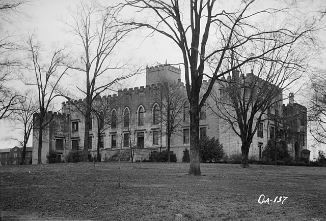
English: Old State Capitol, Milledgeville, Baldwin County, GA - General view. |
|||||
| Date | ||||||
| Source | Library of Congress, Prints and Photographs Division: Historic American Buildings Survey, HABS: GA,5-MILG,6-2 | |||||
| Author | L. D. Andrew, photographer | |||||
| Permission ( Reusing this file) |
|


|
This image is available from the United States
Library of Congress's
Prints and Photographs division
under the digital ID hhh.ga0306. This tag does not indicate the copyright status of the attached work. A normal copyright tag is still required. See Commons:Licensing.
|
File history
Click on a date/time to view the file as it appeared at that time.
| Date/Time | Thumbnail | Dimensions | User | Comment | |
|---|---|---|---|---|---|
| current | 15:00, 5 April 2009 |
| 4,697 × 3,191 (2 MB) | Cropbot | upload cropped version, operated by User:Finavon. Summary: border cropped |
| 02:31, 16 April 2007 |
 | 5,000 × 3,660 (2.19 MB) | Dual Freq | {{Information |Description=Old State Capitol, Milledgeville, Baldwin County, GA. (2. Historic American Buildings Survey L. D. Andrew, Photographer Jan 3, 1937 GENERAL VIEW HABS GA,5-MILG,6-2) {{coor dms|33|04|43|N|083|13|29|W|type:landmark}} |Source=[http |
File usage
The following pages on the English Wikipedia use this file (pages on other projects are not listed):
Global file usage
The following other wikis use this file:
- Usage on ceb.wikipedia.org
- Usage on de.wikipedia.org
- Usage on es.wikipedia.org
- Usage on fa.wikipedia.org
- Usage on la.wikipedia.org
- Usage on pt.wikipedia.org
- Usage on sh.wikipedia.org
- Usage on sr.wikipedia.org
- Usage on uk.wikipedia.org
- Usage on ur.wikipedia.org
- Usage on zh-min-nan.wikipedia.org
- Usage on zh.wikipedia.org