Size of this preview:
725 × 600 pixels. Other resolutions:
290 × 240 pixels |
580 × 480 pixels |
928 × 768 pixels |
1,238 × 1,024 pixels |
2,476 × 2,048 pixels |
2,570 × 2,126 pixels.
Original file (2,570 × 2,126 pixels, file size: 1.59 MB, MIME type: image/jpeg)
| This is a file from the
Wikimedia Commons. Information from its
description page there is shown below. Commons is a freely licensed media file repository. You can help. |
_and_Goodyear_Hall_(rear),_Akron,_Ohio_-_20200926.jpg)
Summary
| Description |
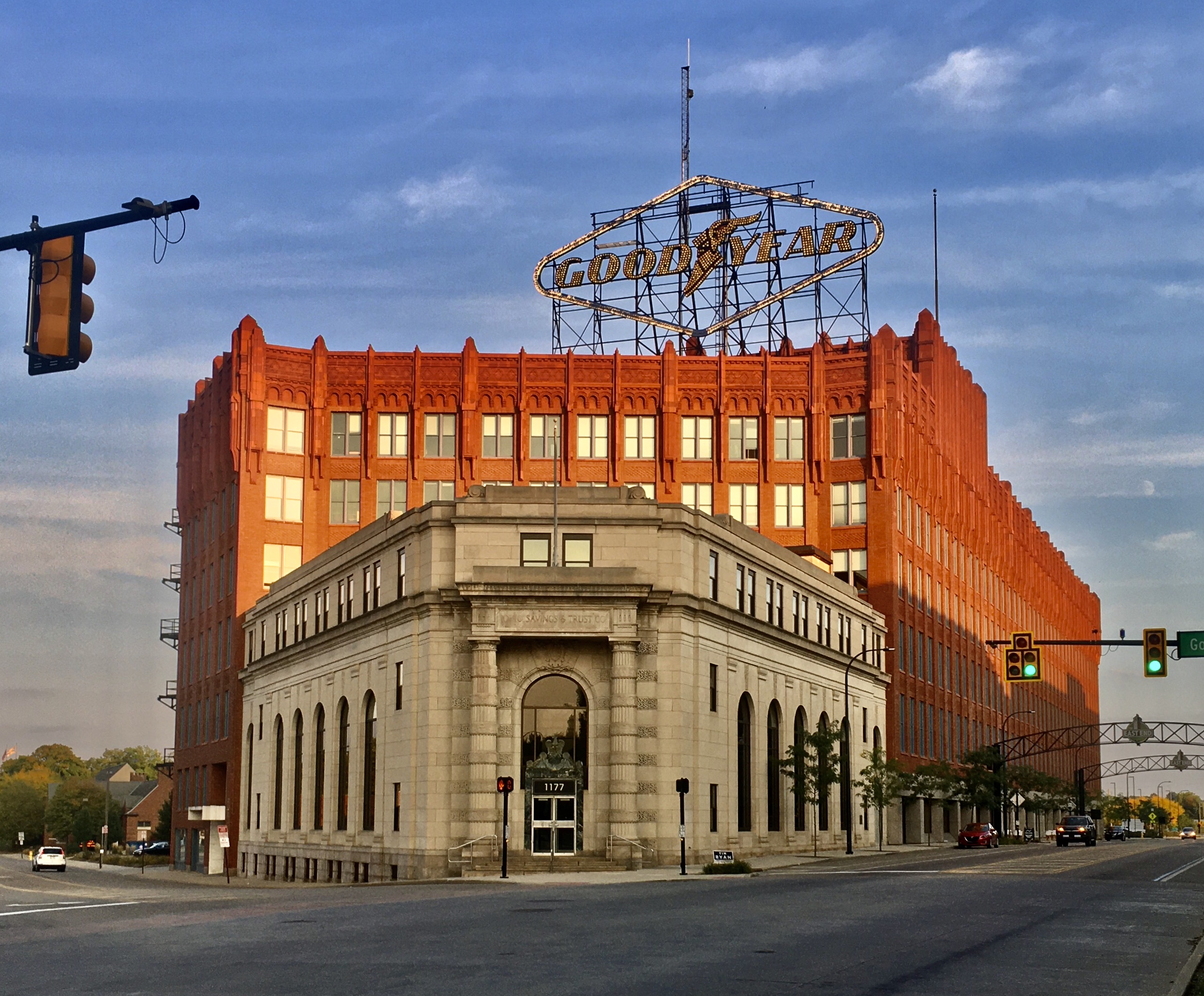
English: This September 2020 view of the southeast corner of East Market Street and Goodyear Boulevard, in the East End of Akron, Ohio, comprises the former Ohio Savings and Trust Company building in the foreground and Goodyear Hall behind it. Both built in 1920 to a design by the Cleveland-based firm of Walker & Weeks, one of Ohio's most prolific of the era, the buildings served various purposes relation to the Goodyear Tire and Rubber Company: the former is exemplary of the Neoclassical style and served as longtime home to Ohio's first company-owned bank (renamed Goodyear State Bank in 1933), the latter a Gothic-Romanesque hybrid faced in brilliant red terra cotta and accpommodating a host of different amenities enjoyed by Goodyear employees: a gynmasium and indoor stadium, bowling alleys, rifle ranges, bathhouses, a large auditorium, library, music rooms, and more. |
| Date | |
| Source | Own work |
| Author | Andre Carrotflower |
| Camera location | | View this and other nearby images on: OpenStreetMap |
|
|---|
_and_Goodyear_Hall_(rear),_Akron,_Ohio_-_20200926.jpg¶ms=041.066894_N_-081.484047_E_globe:Earth_type:camera_heading:119.17&language=en)
Licensing
I, the copyright holder of this work, hereby publish it under the following license:
This file is licensed under the
Creative Commons
Attribution-Share Alike 4.0 International license.
- You are free:
- to share – to copy, distribute and transmit the work
- to remix – to adapt the work
- Under the following conditions:
- attribution – You must give appropriate credit, provide a link to the license, and indicate if changes were made. You may do so in any reasonable manner, but not in any way that suggests the licensor endorses you or your use.
- share alike – If you remix, transform, or build upon the material, you must distribute your contributions under the same or compatible license as the original.
File history
Click on a date/time to view the file as it appeared at that time.
| Date/Time | Thumbnail | Dimensions | User | Comment | |
|---|---|---|---|---|---|
| current | 05:44, 12 November 2020 |
| 2,570 × 2,126 (1.59 MB) | Andre Carrotflower | Uploaded own work with UploadWizard |
File usage
The following pages on the English Wikipedia use this file (pages on other projects are not listed):
Global file usage
The following other wikis use this file:
- Usage on www.wikidata.org
_and_Goodyear_Hall_(rear),_Akron,_Ohio_-_20200926.jpg)