
Size of this preview:
763 × 600 pixels. Other resolutions:
306 × 240 pixels |
611 × 480 pixels |
978 × 768 pixels |
1,280 × 1,006 pixels |
2,560 × 2,011 pixels |
5,600 × 4,400 pixels.
Original file (5,600 × 4,400 pixels, file size: 4.7 MB, MIME type: image/jpeg)
| This is a file from the
Wikimedia Commons. Information from its
description page there is shown below. Commons is a freely licensed media file repository. You can help. |
Summary
| Description |
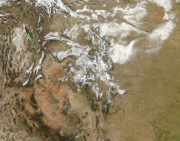
English: Snow highlights the rugged mountains as well as the urban and agricultural landscapes of the plains. During this event, winds were predominantly from the north. Air moving southward from the
Wyoming-Colorado border blew down-slope toward the
South Platte River Valley, and it dropped less snow. On the far side of the river, however, the terrain rises and as the air climbed up-slope, heavier snow fell. The difference in snow totals occurs because air that is descending generally warms and dries. Air that is forced to rise over elevated
topography cools, and more water vapour condenses into rain or snow. This pattern of heavy snow in up-slope (north-facing) areas and less in down-slope areas is repeated across the state, most obviously in river valleys oriented in an east-west direction, including the
Gunnison and
Rio Grande Valleys in Colorado and the
Green River Valley in Utah. |
| Date | |
| Source | NASA Earth Observatory |
| Author | Jeff Schmaltz |
Image captured by the Moderate Resolution Imaging Spectroradiometer (MODIS) on NASA’s Aqua satellite. Image courtesy of the MODIS Rapid Response Team at NASA GSFC.
Licensing
| This file is in the public domain in the United States because it was solely created by NASA. NASA copyright policy states that "NASA material is not protected by copyright unless noted". (See Template:PD-USGov, NASA copyright policy page or JPL Image Use Policy.) | ||
 |
Warnings:
|
| Annotations | This image is annotated: View the annotations at Commons |
File history
Click on a date/time to view the file as it appeared at that time.
| Date/Time | Thumbnail | Dimensions | User | Comment | |
|---|---|---|---|---|---|
| current | 12:25, 4 November 2009 |
| 5,600 × 4,400 (4.7 MB) | Originalwana | {{Information |Description={{en|1=Snow highlights the rugged mountains as well as the urban and agricultural landscapes of the plains. During this event, winds were predominantly from the north. Air moving southward from the Wyoming- |
File usage
No pages on the English Wikipedia use this file (pages on other projects are not listed).
Global file usage
The following other wikis use this file:
- Usage on ja.wikipedia.org