
Size of this preview:
639 × 599 pixels. Other resolutions:
256 × 240 pixels |
512 × 480 pixels |
819 × 768 pixels |
1,092 × 1,024 pixels |
2,195 × 2,059 pixels.
Original file (2,195 × 2,059 pixels, file size: 978 KB, MIME type: image/png)
| This is a file from the
Wikimedia Commons. Information from its
description page there is shown below. Commons is a freely licensed media file repository. You can help. |
Summary
| Description |
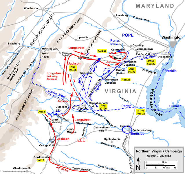
English: Map of the Northern Virginia Campaign of the American Civil War. Drawn by Hal Jespersen in Adobe Illustrator CS5. Graphic source file is available at
http://www.posix.com/CWmaps/ |
| Source | http://www.posix.com/CWmaps/ |
| Author | Hal Jespersen at en.wikipedia |
| Permission ( Reusing this file) |
CC-BY-3.0. |
Licensing
Hal Jespersen at
en.wikipedia, the copyright holder of this work, hereby publishes it under the following license:
This file is licensed under the
Creative Commons
Attribution 3.0 Unported license.
Attribution: Map by Hal Jespersen, www.posix.com/CW
- You are free:
- to share – to copy, distribute and transmit the work
- to remix – to adapt the work
- Under the following conditions:
- attribution – You must give appropriate credit, provide a link to the license, and indicate if changes were made. You may do so in any reasonable manner, but not in any way that suggests the licensor endorses you or your use.
File history
Click on a date/time to view the file as it appeared at that time.
| Date/Time | Thumbnail | Dimensions | User | Comment | |
|---|---|---|---|---|---|
| current | 19:42, 24 March 2011 |
| 2,195 × 2,059 (978 KB) | Hlj | Update graphical style of rivers and roads. Minor cleanup. Same license. |
| 20:45, 22 June 2009 |
 | 1,500 × 1,413 (485 KB) | DR | {{Information |Description={{en|1=Map of the Northern Virginia Campaign of the American Civil War. Drawn by Hal Jespersen in Adobe Illustrator. Graphic source file is available at http://www.posix.com/CWmaps/}} |Source=http://www.posix.com/CWmaps/ |Author |
File usage
The following pages on the English Wikipedia use this file (pages on other projects are not listed):
Global file usage
The following other wikis use this file:
- Usage on azb.wikipedia.org
- Usage on ca.wikipedia.org
- Usage on es.wikipedia.org
- Usage on fa.wikipedia.org
- Usage on fr.wikipedia.org
- Usage on hu.wikipedia.org
- Usage on it.wikipedia.org
- Usage on nl.wikipedia.org
- Usage on no.wikipedia.org
- Usage on pt.wikipedia.org
- Usage on ru.wikipedia.org
- Usage on vi.wikipedia.org