No higher resolution available.
North_Woods.gif (720 × 480 pixels, file size: 17 KB, MIME type: image/gif)
| This is a file from the
Wikimedia Commons. Information from its
description page there is shown below. Commons is a freely licensed media file repository. You can help. |
Summary
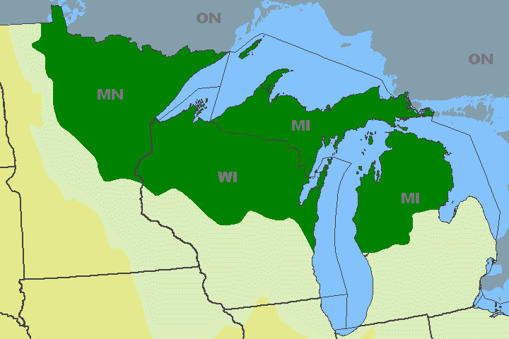
English: Map of the
Laurentian Mixed Forest Province (North Woods) of North America,
- in the U. S. states of Minnesota, Wisconsin, and Michigan;
- in the Temperate broadleaf and mixed forests Biome.
From National Atlas Mapmaker archive copy at the Wayback Machine; province recolored green.
Italiano: Mappa dell'area della
Foresta mista laurenziana (North Woods) nel Nord America.
- Località negli stati USA di Minnesota, Wisconsin, e Michigan dell' Upper Midwest.
- Rientra nel bioma Foresta temperata.
Dal National Atlas Mapmaker archive copy at the Wayback Machine; area ricolorata di verde.
Licensing
This map was obtained from an edition of the
National Atlas of the United States. Like almost all works of the U.S. federal government, works from the National Atlas are in the
public domain in the United States.
Online access: NationalAtlas.gov | 1970 print edition: Library of Congress, Perry-Castañeda Library
|
File history
Click on a date/time to view the file as it appeared at that time.
| Date/Time | Thumbnail | Dimensions | User | Comment | |
|---|---|---|---|---|---|
| current | 01:43, 2 October 2009 |
| 720 × 480 (17 KB) | Kablammo | == {{int:filedesc}} == Map of the Laurentian Mixed Forest Province ( North Woods) of the Upper Midwestern U. S. states of Minnesota, Wisconsin, and [[:en:Mich |
File usage
The following pages on the English Wikipedia use this file (pages on other projects are not listed):
Global file usage
The following other wikis use this file:
- Usage on ar.wikipedia.org
- Usage on it.wikipedia.org
- Usage on ro.wikipedia.org
- Categorie:Statul Wisconsin, SUA
- Wisconsin
- Format:Wisconsin stat SUA
- Milwaukee, Wisconsin
- Madison, Wisconsin
- Categorie:Formate Wisconsin
- Categorie:Membri ai Senatului SUA din statul Wisconsin
- Categorie:Liste Wisconsin
- Comitatul Marquette, Wisconsin
- Lacul Michigan
- Categorie:Guvernatori ai statului Wisconsin
- Listă de oameni din statul Wisconsin
- Categorie:Racine, Wisconsin
- Comitatul Dane, Wisconsin
- Comitatul Marinette, Wisconsin
- Listă de comitate din statul Wisconsin
- Comitatul Adams, Wisconsin
- Categorie:Comitatul Adams, Wisconsin
- Comitatul Ashland, Wisconsin
- Comitatul Barron, Wisconsin
- Comitatul Bayfield, Wisconsin
- Comitatul Brown, Wisconsin
- Comitatul Buffalo, Wisconsin
- Categorie:Comitatul Buffalo, Wisconsin
- Comitatul Burnett, Wisconsin
- Comitatul Calumet, Wisconsin
- Comitatul Chippewa, Wisconsin
- Comitatul Clark, Wisconsin
- Comitatul Columbia, Wisconsin
- Comitatul Crawford, Wisconsin
- Comitatul Dodge, Wisconsin
- Categorie:Guvernul statului Wisconsin
- Categorie:Prefixe telefonice în Wisconsin
- Ashland, Wisconsin
- Comitatul Douglas, Wisconsin
- Categorie:Comitatul Polk, Wisconsin
- Friendship, Wisconsin
- Comitatul Fond du Lac, Wisconsin
- Racine, Wisconsin
- Categorie:Zone metropolitane din Wisconsin
- Categorie:Zone micropolitane din Wisconsin
- Categorie:Localități din Wisconsin
- Categorie:Membri ai Camerei Reprezentanților SUA din statul Wisconsin
- Categorie:Forme de relief din Wisconsin
- Categorie:Regiuni ale statului Wisconsin
- Green Bay, Wisconsin
- Comitatul Dunn, Wisconsin
- Comitatul Eau Claire, Wisconsin
View more global usage of this file.