
Size of this preview:
471 × 599 pixels. Other resolutions:
189 × 240 pixels |
377 × 480 pixels |
604 × 768 pixels |
805 × 1,024 pixels |
2,119 × 2,694 pixels.
Original file (2,119 × 2,694 pixels, file size: 1.29 MB, MIME type: image/jpeg)
| This is a file from the
Wikimedia Commons. Information from its
description page there is shown below. Commons is a freely licensed media file repository. You can help. |
Summary
| Description |
English:
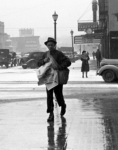
Paperboy,
Iowa City, Iowa, 1940, by
Arthur Rothstein. This is a cropped image, looking east into the 200 block of Washington Street. Although cropped from this image, the Jefferson Hotel is just right of the carrier (to his left) at a spot now the storefront of Herteen & Stocker Jewelers. The building in the immediate background was demolished to make space for Blackhawk Minipark, now part of the downtown Pedmall (pedestrian walkway) which occupies that block of Dubuque Street. The theater marquee in the background to the right of the carrier is for the historic
Englert Theatre at 221 Washington Street.
|
|||||||||||||||||||||||
| Date | ||||||||||||||||||||||||
| Source |
|
|||||||||||||||||||||||
| Author |
|
|||||||||||||||||||||||

.jpg)
| Camera location | | View this and other nearby images on: OpenStreetMap |
|
|---|
Licensing
| This image is a work of an employee of the United States Farm Security Administration or Office of War Information domestic photographic units, taken as part of that person's official duties. As a work of the U.S. federal government, the image is in the public domain in the United States. See Copyright. |
Transwiki details
Also uploaded to en:Wikipedia; page is/was here. All following user names refer to en.wikipedia.
- 2010-07-25 03:46 Billwhittaker 2119×2694× (1348198 bytes) {{Information |Description = [[Paperboy]], [[Iowa City]], 1940 |Source = http://www.loc.gov/pictures/item/fsa1997013024/PP |Date = ~~~~~ |Author = Rothstein, Arthur: US Farm Security Administration |Permission = |ot
File history
Click on a date/time to view the file as it appeared at that time.
| Date/Time | Thumbnail | Dimensions | User | Comment | |
|---|---|---|---|---|---|
| current | 16:48, 8 September 2011 |
| 2,119 × 2,694 (1.29 MB) | File Upload Bot (Magnus Manske) | {{BotMoveToCommons|en.wikipedia|year={{subst:CURRENTYEAR}}|month={{subst:CURRENTMONTHNAME}}|day={{subst:CURRENTDAY}}}} {{Information |Description={{en| en:Paperboy, en:Iowa City, 1940, by en:Arthur Rothstein. This is a cropped image, loo |
File usage
The following pages on the English Wikipedia use this file (pages on other projects are not listed):
Global file usage
The following other wikis use this file:
- Usage on ar.wikipedia.org
- Usage on cs.wikipedia.org
- Usage on is.wikipedia.org
- Usage on lmo.wiktionary.org
- Usage on pl.wikipedia.org
- Usage on uk.wikipedia.org
- Usage on vi.wikipedia.org