Size of this preview:
519 × 599 pixels. Other resolutions:
208 × 240 pixels |
416 × 480 pixels |
665 × 768 pixels |
887 × 1,024 pixels |
1,774 × 2,048 pixels |
3,899 × 4,500 pixels.
Original file (3,899 × 4,500 pixels, file size: 4.88 MB, MIME type: image/jpeg)
| This is a file from the
Wikimedia Commons. Information from its
description page there is shown below. Commons is a freely licensed media file repository. You can help. |
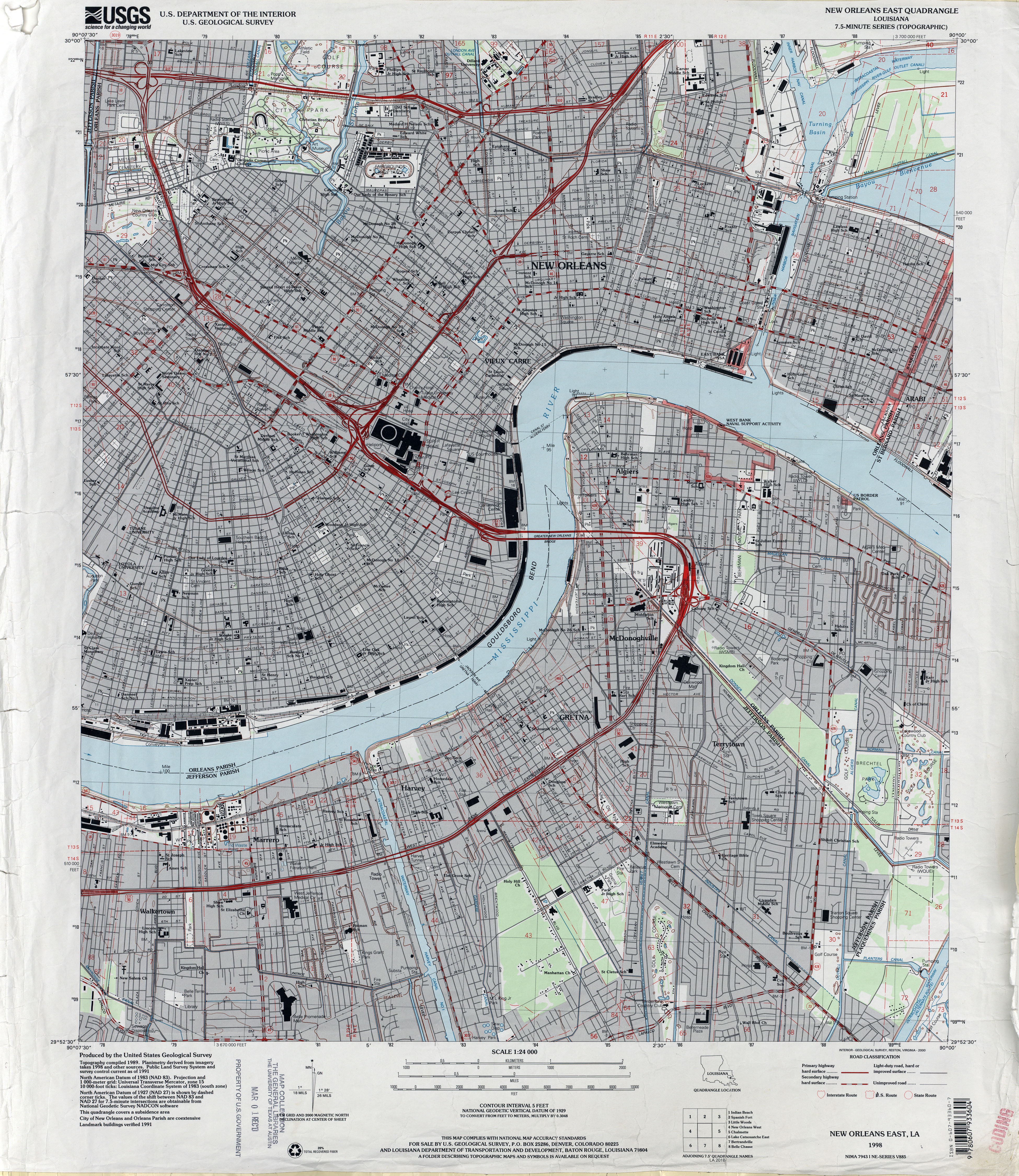
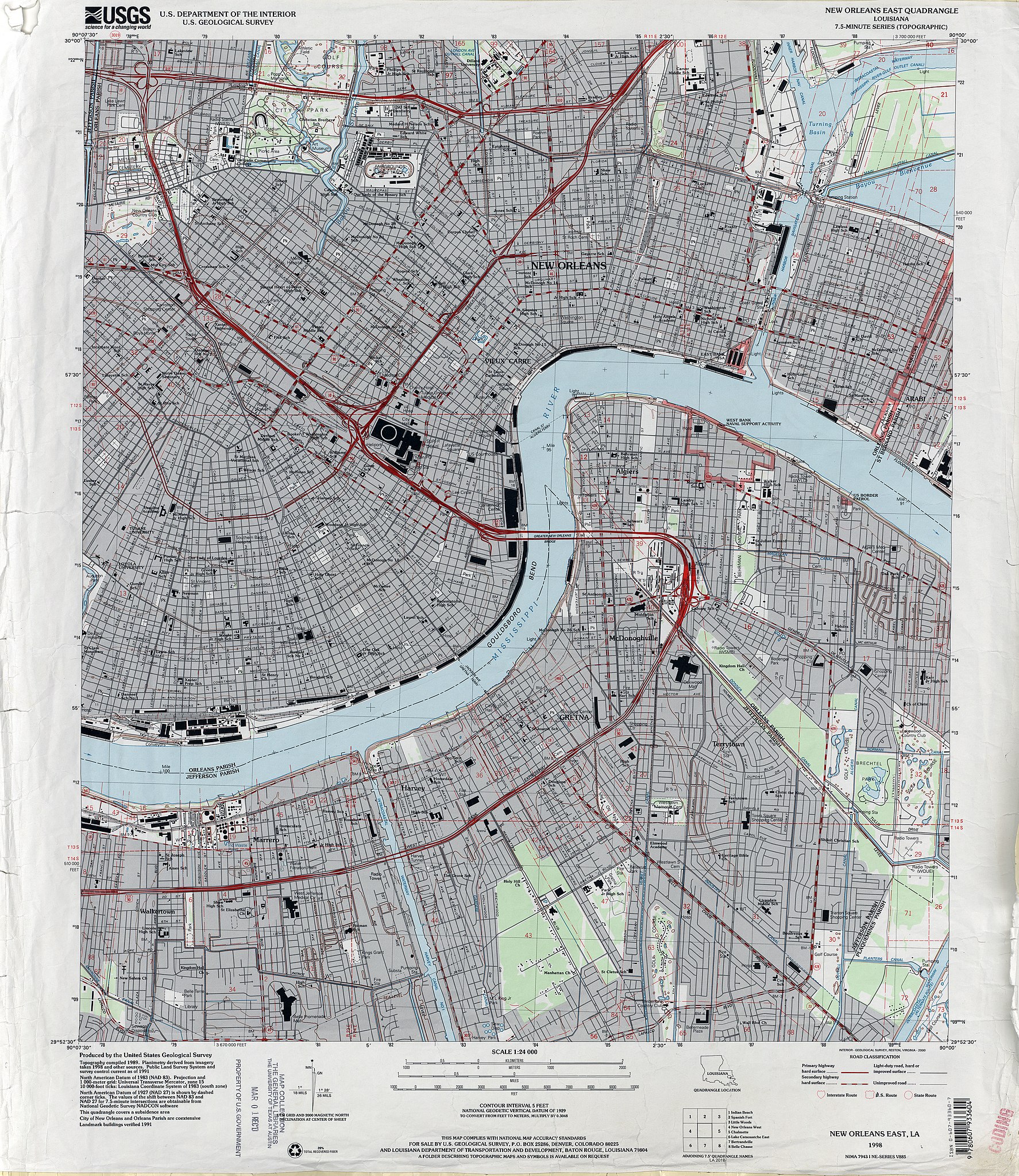
| Description | 1998 map of New Orleans, showing the section of the city closer to the Mississippi River, from about Mid-City to just below Audubon Park to the Lower 9th Ward, together with Algiers and the West Bank Jefferson Parish suburbs including Marrero, Harvey, Gretna. | |||
| Date | ||||
| Source | U.S. Geological Survey map, 1998, via [1] | |||
| Author | U.S. Geological Survey | |||
| Permission ( Reusing this file) |
|
File history
Click on a date/time to view the file as it appeared at that time.
| Date/Time | Thumbnail | Dimensions | User | Comment | |
|---|---|---|---|---|---|
| current | 22:52, 19 June 2012 |
| 3,899 × 4,500 (4.88 MB) | Infrogmation | {{Information |Description= 1998 map of New Orleans, showing the section of the city closer to the Mississippi River, from about Mid-City to just below Audubon Park to the Lower 9th Ward, together with Algiers and the West Bank Jefferson Parish suburbs... |
File usage
The following pages on the English Wikipedia use this file (pages on other projects are not listed):
- Aldrich–Genella House
- Algiers Point
- American Chicle Company Building
- Arabella Station
- Bank of Louisiana
- Blue Plate Building
- Bohn Motor Company Automobile Dealership
- Caesars Superdome
- Confederate Memorial Hall Museum
- Congo Square
- Gallier Hall
- Gallier House
- General Beauregard Equestrian Statue
- George Washington Cable House
- Gretna, Louisiana
- Harvey, Louisiana
- Hermann–Grima House
- Huey P. Long Mansion
- Jackson Barracks
- Jackson Square (New Orleans)
- John Minor Wisdom United States Court of Appeals Building
- Lafayette Cemetery No. 1
- Lafitte's Blacksmith Shop
- Longue Vue House and Gardens
- Louisiana State Bank Building
- Madame John's Legacy
- Marrero, Louisiana
- Metairie Cemetery
- Napoleon House
- National American Bank Building
- New Orleans Cotton Exchange
- New Orleans Jazz National Historical Park
- New Orleans Mint
- Odd Fellows Rest Cemetery
- Old Ursuline Convent, New Orleans
- Orpheum Theater (New Orleans)
- Perseverance Hall
- Pitot House
- Pontalba Buildings
- Robert E. Lee Monument (New Orleans)
- Saenger Theatre (New Orleans)
- St. Alphonsus Church, New Orleans
- St. Charles Streetcar Line
- St. James AME Church (New Orleans, Louisiana)
- St. Mary's Assumption Church (New Orleans, Louisiana)
- St. Patrick's Church (New Orleans, Louisiana)
- St. Peter A.M.E. Church
- St. Vincent De Paul Roman Catholic Church (New Orleans, Louisiana)
- The Presbytere
- U.S. Army Supply Base New Orleans
- Union Bethel A.M.E. Church (New Orleans, Louisiana)
- United States Custom House (New Orleans)
- Vieux Carre Property Owners, Residents and Associates
- Module:Location map/data/United States New Orleans East
- Module:Location map/data/United States New Orleans East/doc
Global file usage
The following other wikis use this file:
- Usage on si.wikipedia.org
- Usage on vi.wikipedia.org