
Size of this preview:
550 × 600 pixels. Other resolutions:
220 × 240 pixels |
440 × 480 pixels |
704 × 768 pixels |
939 × 1,024 pixels |
1,878 × 2,048 pixels |
4,007 × 4,370 pixels.
Original file (4,007 × 4,370 pixels, file size: 1.09 MB, MIME type: image/jpeg)
| This is a file from the
Wikimedia Commons. Information from its
description page there is shown below. Commons is a freely licensed media file repository. You can help. |
Summary
| Description |
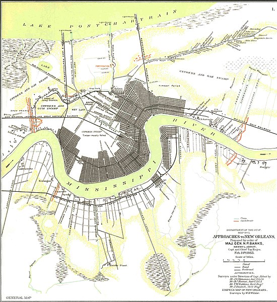
English: Department of the Gulf Map Number 5, Approaches to New Orleans prepared by order of Major General N.P. Banks, February 14th, 1863 |
| Date | 03:15, 3 June 2010 (UTC) |
| Source | The Official Military Atlas of the Civil War, Government Printing Office, 1983 Edition |
| Author | U.S. Army Military History Institute |
Licensing
This file is a work of a
U.S. Army soldier or employee, taken or made as part of that person's official duties. As a
work of the
U.S. federal government, it is in the
public domain in the United States.
|
 |
Original upload log
The original description page was
here. All following user names refer to en.wikipedia.
| Date/Time | Dimensions | User | Comment |
|---|---|---|---|
| 2010-06-03 03:15 | 4007×4370× (1138428 bytes) | Calendar5 | {{Information |Description = Department of the Gulf Map Number 5, Approaches to New Orleans prepared by order of Major General N.P. Banks, February 14th, 1863 |Source = The Official Military Atlas of the Civil War, Government Printing Office, |
File history
Click on a date/time to view the file as it appeared at that time.
| Date/Time | Thumbnail | Dimensions | User | Comment | |
|---|---|---|---|---|---|
| current | 07:38, 17 June 2018 |
| 4,007 × 4,370 (1.09 MB) | Tikky19 | Transferred from en.wikipedia via #commonshelper |
File usage
The following pages on the English Wikipedia use this file (pages on other projects are not listed):
Global file usage
The following other wikis use this file:
- Usage on fr.wikipedia.org