No higher resolution available.
Netherlands-CIA_WFB_Map-10-10-10.png (330 × 353 pixels, file size: 68 KB, MIME type: image/png)
| This is a file from the
Wikimedia Commons. Information from its
description page there is shown below. Commons is a freely licensed media file repository. You can help. |
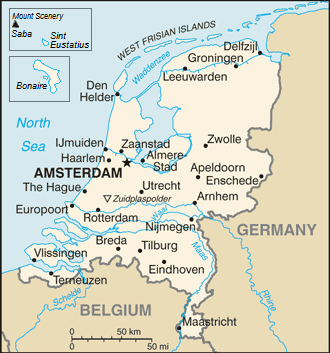
| Description | Map of the Netherlands |
| Date | (UTC) |
| Source | |
| Author |
|
| This is a
retouched picture, which means that it has been digitally altered from its original version. The original can be viewed here:
Netherlands-CIA WFB Map.png:
|
This image is in the
public domain because it contains materials that originally came from the United States
Central Intelligence Agency's
World Factbook.
|
 |
Original upload log
This image is a derivative work of the following images:
- File:Netherlands-CIA_WFB_Map.png licensed with PD-USGov-CIA-WF
Uploaded with derivativeFX
File history
Click on a date/time to view the file as it appeared at that time.
| Date/Time | Thumbnail | Dimensions | User | Comment | |
|---|---|---|---|---|---|
| current | 16:17, 14 September 2019 |
| 330 × 353 (68 KB) | Thayts | Borkum to Germany |
| 11:40, 7 December 2010 |
 | 330 × 353 (33 KB) | LennartBolks~commonswiki | {{Information |Description=Map of the Netherlands |Source=* File:Netherlands-CIA_WFB_Map.png |Date=2010-12-07 11:39 (UTC) |Author=* File:Netherlands-CIA_WFB_Map.png: CIA *derivative work: ~~~ |Permission= |other_versions= }} {{RetouchedPicture| |
File usage
The following pages on the English Wikipedia use this file (pages on other projects are not listed):
Global file usage
The following other wikis use this file:
- Usage on dsb.wikipedia.org
- Usage on en.wikiversity.org
- Usage on gom.wikipedia.org
- Usage on incubator.wikimedia.org
- Usage on ja.wikipedia.org
- Usage on lt.wiktionary.org
- Usage on ms.wikipedia.org
- Usage on mt.wikipedia.org
- Usage on my.wikipedia.org
- Usage on pl.wikipedia.org
- Usage on pl.wikivoyage.org
- Usage on ps.wikipedia.org
- Usage on pt.wikipedia.org
- Usage on ro.wikipedia.org
- Usage on simple.wikipedia.org
- Usage on sq.wikipedia.org
- Usage on szl.wikipedia.org
- Usage on to.wikipedia.org
- Usage on www.wikidata.org