
Size of this PNG preview of this SVG file:
800 × 474 pixels. Other resolutions:
320 × 190 pixels |
640 × 380 pixels |
1,024 × 607 pixels |
1,280 × 759 pixels |
2,560 × 1,518 pixels |
1,450 × 860 pixels.
Original file (SVG file, nominally 1,450 × 860 pixels, file size: 574 KB)
| This is a file from the
Wikimedia Commons. Information from its
description page there is shown below. Commons is a freely licensed media file repository. You can help. |
Summary
| Description |
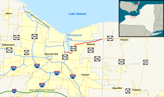
English: Map of
New York State Route 404. Base map made in Quantum GIS using GIS data from the United States Census Bureau (
TIGER) and the Federal Highway Administration (
NHPN), and enhanced using Inkscape. This map uses public domain SVG route markers available on Wikimedia Commons. |
| Date | |
| Source | Own work |
| Author | TwinsMetsFan |
| SVG development |
Licensing
| I, the copyright holder of this work, release this work into the
public domain. This applies worldwide. In some countries this may not be legally possible; if so: I grant anyone the right to use this work for any purpose, without any conditions, unless such conditions are required by law. |
File history
Click on a date/time to view the file as it appeared at that time.
| Date/Time | Thumbnail | Dimensions | User | Comment | |
|---|---|---|---|---|---|
| current | 05:58, 11 February 2011 |
| 1,450 × 860 (574 KB) | TwinsMetsFan | {{Information |Description ={{en|1=Map of New York State Route 404. Base map made in Quantum GIS using GIS data from the United States Census Bureau ([http://arcdata.esri.com/data/tiger2000/tiger_download.cfm TIGER]) an |
File usage
The following pages on the English Wikipedia use this file (pages on other projects are not listed):
Global file usage
The following other wikis use this file:
- Usage on www.wikidata.org