
Size of this preview:
800 × 484 pixels. Other resolutions:
320 × 193 pixels |
640 × 387 pixels |
1,024 × 619 pixels |
1,280 × 774 pixels |
1,833 × 1,108 pixels.
Original file (1,833 × 1,108 pixels, file size: 1.91 MB, MIME type: image/jpeg)
| This is a file from the
Wikimedia Commons. Information from its
description page there is shown below. Commons is a freely licensed media file repository. You can help. |
.jpg)
Summary
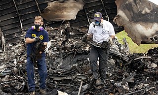
| Description | NTSB investigators remove the recorders from UPS 1354. |
| Date | |
| Source | NTSB investigators remove the recorders from UPS 1354 |
| Author | National Transportation Safety Board |
| Camera location |
| View this and other nearby images on: OpenStreetMap |
|
|---|
.jpg¶ms=033.525940_N_-086.801605_E_globe:Earth_type:camera_source:Flickr_&language=en)
Licensing
| This image was originally posted to Flickr by NTSBgov at https://flickr.com/photos/68618467@N03/9518908718 ( archive). It was reviewed on 4 August 2018 by FlickreviewR 2 and was confirmed to be licensed under the terms of the Public Domain Mark. |
This image is a work of a
National Transportation Safety Board employee, taken or made as part of an employee's official duties. As a
work of the
U.S. federal government, all NTSB images are in the
public domain in the United States.
|
File history
Click on a date/time to view the file as it appeared at that time.
| Date/Time | Thumbnail | Dimensions | User | Comment | |
|---|---|---|---|---|---|
| current | 14:01, 4 August 2018 |
| 1,833 × 1,108 (1.91 MB) | MarginalCost | Transferred from Flickr via #flickr2commons |
File usage
The following pages on the English Wikipedia use this file (pages on other projects are not listed):
.jpg)