
Size of this PNG preview of this SVG file:
776 × 600 pixels. Other resolutions:
311 × 240 pixels |
621 × 480 pixels |
994 × 768 pixels |
1,280 × 989 pixels |
2,560 × 1,978 pixels |
990 × 765 pixels.
Original file (SVG file, nominally 990 × 765 pixels, file size: 12.04 MB)
| This is a file from the
Wikimedia Commons. Information from its
description page there is shown below. Commons is a freely licensed media file repository. You can help. |
Summary
| Description |
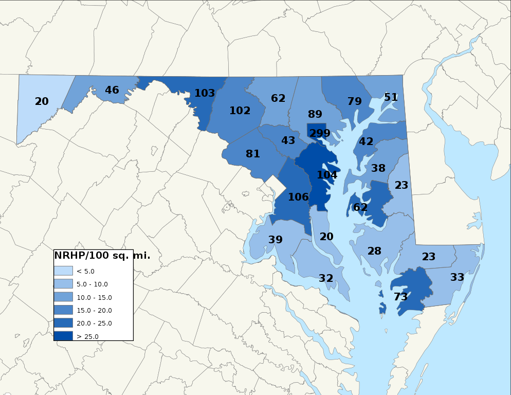
English: Map of Maryland NRHP/100 sq. mi., by county. As of 12/11/09
|
||
| Source | Own work | ||
| Author | 25or6to4 |
Licensing
I, the copyright holder of this work, hereby publish it under the following licenses:
This file is licensed under the
Creative Commons
Attribution-Share Alike 3.0 Unported license.
- You are free:
- to share – to copy, distribute and transmit the work
- to remix – to adapt the work
- Under the following conditions:
- attribution – You must give appropriate credit, provide a link to the license, and indicate if changes were made. You may do so in any reasonable manner, but not in any way that suggests the licensor endorses you or your use.
- share alike – If you remix, transform, or build upon the material, you must distribute your contributions under the same or compatible license as the original.

|
Permission is granted to copy, distribute and/or modify this document under the terms of the GNU Free Documentation License, Version 1.2 or any later version published by the Free Software Foundation; with no Invariant Sections, no Front-Cover Texts, and no Back-Cover Texts. A copy of the license is included in the section entitled GNU Free Documentation License. |
You may select the license of your choice.
File history
Click on a date/time to view the file as it appeared at that time.
| Date/Time | Thumbnail | Dimensions | User | Comment | |
|---|---|---|---|---|---|
| current | 06:44, 11 April 2022 |
| 990 × 765 (12.04 MB) | 25or6to4 | Updated through March 2022 |
| 09:30, 23 March 2019 |
 | 990 × 765 (5.73 MB) | 25or6to4 | Updated through March 1, 2019. | |
| 17:55, 15 September 2014 |
 | 792 × 612 (2.07 MB) | 25or6to4 | Updated through September 2014 | |
| 07:13, 16 September 2012 |
 | 792 × 612 (633 KB) | 25or6to4 | updated through August 2012 | |
| 10:32, 20 December 2009 |
 | 792 × 612 (420 KB) | 25or6to4 | {{Information |Description={{en|1=Map of Maryland NRHP/100 sq. mi., by county. As of 12/11/09}} |Source={{own}} |Author= 25or6to4 |Date= |Permission= |other_versions= }} Category:Maps of Maryland [[Category:National Register of Hist |
File usage
The following pages on the English Wikipedia use this file (pages on other projects are not listed):
Global file usage
The following other wikis use this file:
- Usage on de.wikipedia.org
- Usage on pt.wikipedia.org
- Usage on ro.wikipedia.org
- Categorie:Statul Maryland, SUA
- Maryland
- Format:Maryland stat SUA
- Listă de orașe din statul Maryland
- Listă de comitate din statul Maryland
- Annapolis, Maryland
- Rockville, Maryland
- Categorie:Liste Maryland
- Cumberland, Maryland
- Categorie:Oameni din Baltimore, Maryland
- Listă de oameni din statul Maryland
- Drapelul statului Maryland
- Categorie:Guvernul statului Maryland
- Categorie:Sedii de comitate din Maryland
- Berlin, Maryland
- Categorie:Comitatul Anne Arundel, Maryland
- Comitatul Anne Arundel, Maryland
- Categorie:Comitatul Allegany, Maryland
- Categorie:Comitatul Baltimore, Maryland
- Categorie:Comitatul Calvert, Maryland
- Categorie:Comitatul Carroll, Maryland
- Categorie:Comitatul Charles, Maryland
- Categorie:Comitatul Dorchester, Maryland
- Categorie:Comitatul Frederick, Maryland
- Categorie:Comitatul Garrett, Maryland
- Categorie:Comitatul Harford, Maryland
- Categorie:Comitatul Howard, Maryland
- Categorie:Comitatul Kent, Maryland
- Categorie:Comitatul Montgomery, Maryland
- Categorie:Comitatul Queen Anne, Maryland
- Categorie:Comitatul Saint Mary, Maryland
- Categorie:Comitatul Somerset, Maryland
- Categorie:Comitatul Talbot, Maryland
- Categorie:Comitatul Washington, Maryland
- Categorie:Comitatul Wicomico, Maryland
- Categorie:Comitatul Worcester, Maryland
- Comitatul Baltimore, Maryland
- Categorie:Comitatul Caroline, Maryland
- Comitatul Allegany, Maryland
- Categorie:Zone metropolitane din Maryland
- Categorie:Zone micropolitane din Maryland
- Categorie:Oameni din comitatul Worcester, Maryland
- Categorie:Localități din Maryland
- Categorie:Regiuni ale statului Maryland
- Categorie:Dezastre naturale din statul Maryland
- Middletown, Maryland
- Listă de comunități neîncorporate din statul Maryland
- Categorie:Absolvenți din Maryland după instituția de învățământ superior
View more global usage of this file.