
Size of this preview:
533 × 600 pixels. Other resolutions:
213 × 240 pixels |
426 × 480 pixels |
682 × 768 pixels |
910 × 1,024 pixels |
2,202 × 2,478 pixels.
Original file (2,202 × 2,478 pixels, file size: 2.02 MB, MIME type: image/png)
| This is a file from the
Wikimedia Commons. Information from its
description page there is shown below. Commons is a freely licensed media file repository. You can help. |
Summary
| Description |
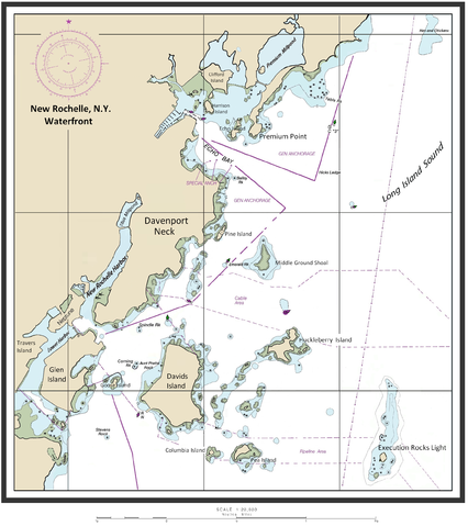
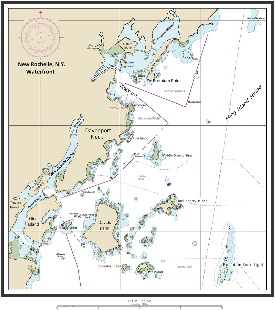
English: Map of New Rochelle waterfront including the harbor management areas, islands, and inlets. |
| Date | 14 February 2015 (original upload date) |
| Source | I ( ClarckeBAR ( talk)) created this work (custom map of New Rochelle Harbor Area with names/locations of geographic features, landforms). Underlying/base map data provided by The National Oceanic and Atmospheric Administration for use in nautical chart production. ( see print example (Western LIS) of published NOAA nautical chart). Main data source - The Seamless Raster Navigational Chart Server, under the following "Copyright Notice" - As required by 17 U.S.C. 403, third parties producing copyrighted works consisting predominantly of the material produced by U.S. government agencies must provide notice with such work(s) identifying the U.S. Government material incorporated and stating that such material is not subject to copyright protection within the United States. The information on government web pages is in the public domain and not subject to copyright protection within the United States unless specifically annotated otherwise (copyright may be held elsewhere). Foreign copyrights may apply. |
| Author | ClarckeBAR at English Wikipedia |
Licensing
ClarckeBAR, the copyright holder of this work, hereby publishes it under the following license:
This file is licensed under the
Creative Commons
Attribution 3.0 Unported license.
Attribution:
ClarckeBAR
- You are free:
- to share – to copy, distribute and transmit the work
- to remix – to adapt the work
- Under the following conditions:
- attribution – You must give appropriate credit, provide a link to the license, and indicate if changes were made. You may do so in any reasonable manner, but not in any way that suggests the licensor endorses you or your use.
Original upload log
The original description page was
here. All following user names refer to en.wikipedia.
| Date/Time | Dimensions | User | Comment |
|---|---|---|---|
| 2015-02-14 10:46 | 2202×2478× (2113870 bytes) | ClarckeBAR | {{Information |Description = Map of New Rochelle waterfront including the harbor management areas, islands, and inlets. |Source = I (~~~) created this work entirely by myself. |Date = ~~~~~ |Author = ~~~ |other_version... |
File history
Click on a date/time to view the file as it appeared at that time.
| Date/Time | Thumbnail | Dimensions | User | Comment | |
|---|---|---|---|---|---|
| current | 06:28, 4 September 2015 |
| 2,202 × 2,478 (2.02 MB) | Innotata | Transferred from en.wikipedia |
File usage
The following pages on the English Wikipedia use this file (pages on other projects are not listed):
- Columbia Island (New York)
- Davenport Neck
- Echo Bay (Long Island Sound)
- New Rochelle Harbor (Long Island Sound)
- Pea Island (New Rochelle, New York)
- Pine Island (New Rochelle)
- Premium Mill-Pond
- Premium Point, New Rochelle
- Titus Mill-Pond & New York State Tidal Wetlands
- Travers Island, New York
- Westchester County, New York
Global file usage
The following other wikis use this file:
- Usage on ceb.wikipedia.org
- Usage on de.wikipedia.org
- Usage on fi.wikipedia.org
- Usage on fr.wikipedia.org
- Usage on ja.wikipedia.org
- Usage on www.wikidata.org