
Size of this preview:
618 × 599 pixels. Other resolutions:
248 × 240 pixels |
495 × 480 pixels |
792 × 768 pixels |
1,056 × 1,024 pixels.
Original file (1,056 × 1,024 pixels, file size: 652 KB, MIME type: image/jpeg)
| This is a file from the
Wikimedia Commons. Information from its
description page there is shown below. Commons is a freely licensed media file repository. You can help. |
Summary
| Description |
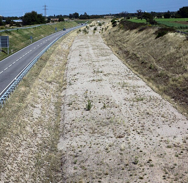
Deutsch: Die Trasse der geplanten Neubaustrecke Karlsruhe–Rastatt-Süd, im Bild die Rampe zum Anschluß an die bisherige Strecke in Höhe Durmersheim English: The route of the planned new-build Karlsruhe–Rastatt South train line; view of the ramp up to the existing train line near Durmersheim |
| Date | |
| Source | Own work |
| Author | Norbert Hüttisch, Karlsruhe |
| Other versions | auf Nachfrage/on request |
| Object location |
| View this and other nearby images on: OpenStreetMap |
|
|---|
| Camera location |
| View this and other nearby images on: OpenStreetMap |
|
|---|
Licensing
I, the copyright holder of this work, hereby publish it under the following license:
This file is licensed under the
Creative Commons
Attribution-Share Alike 3.0 Unported license.
- You are free:
- to share – to copy, distribute and transmit the work
- to remix – to adapt the work
- Under the following conditions:
- attribution – You must give appropriate credit, provide a link to the license, and indicate if changes were made. You may do so in any reasonable manner, but not in any way that suggests the licensor endorses you or your use.
- share alike – If you remix, transform, or build upon the material, you must distribute your contributions under the same or compatible license as the original.
File history
Click on a date/time to view the file as it appeared at that time.
| Date/Time | Thumbnail | Dimensions | User | Comment | |
|---|---|---|---|---|---|
| current | 07:30, 11 December 2011 |
| 1,056 × 1,024 (652 KB) | Rotatebot | Bot: Image rotated by 90° (EXIF-Orientation set from 8 to 1, rotated 0°) |
| 17:06, 1 September 2009 |
 | 1,024 × 1,056 (652 KB) | Nobbipunktcom | {{Information |Description={{de|1=Die Trasse der geplanten Neubaustrecke Karlsruhe–Rastatt-Süd, im Bild die Rampe zum Anschluß an die bisherige Strecke in Höhe Durmersheim}} |Source=own work |Author=Norbert Hüttisch, Karlsruhe |Date=2009-09-01 |Perm |
File usage
The following pages on the English Wikipedia use this file (pages on other projects are not listed):
Global file usage
The following other wikis use this file:
- Usage on de.wikipedia.org