
Original file (SVG file, nominally 1,600 × 1,380 pixels, file size: 62 KB)
| This is a file from the
Wikimedia Commons. Information from its
description page there is shown below. Commons is a freely licensed media file repository. You can help. |
Summary
| Description |
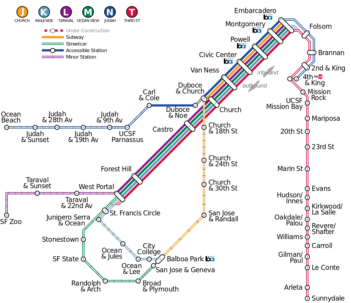
English: Map of Muni Metro subway/light rail/streetcar system in San Francisco, omitting Central Subway tunnel (under construction as of 2016) and current routing for T-Third. |
|||||
| Date | ||||||
| Source |
Own work, derived from sources listed below:
|
|||||
| Author | Mliu92 | |||||
| Permission ( Reusing this file) |
Caltrain and BART logos reused as public domain images:
|
|||||
| Other versions |
This file was derived from:
|


.svg)
.svg)
Licensing
- You are free:
- to share – to copy, distribute and transmit the work
- to remix – to adapt the work
- Under the following conditions:
- attribution – You must give appropriate credit, provide a link to the license, and indicate if changes were made. You may do so in any reasonable manner, but not in any way that suggests the licensor endorses you or your use.
- share alike – If you remix, transform, or build upon the material, you must distribute your contributions under the same or compatible license as the original.
File history
Click on a date/time to view the file as it appeared at that time.
| Date/Time | Thumbnail | Dimensions | User | Comment | |
|---|---|---|---|---|---|
| current | 14:07, 22 March 2016 |
| 1,600 × 1,380 (62 KB) | Mliu92 | Redrawn using plotted coordinates for actual MUNI stops, simplifying to increments of 45-degrees. |
| 16:11, 21 March 2016 |
 | 1,610 × 1,060 (59 KB) | Mliu92 | Rerouted N Judah and T Third (better matches actual geography); rerouted outbound J Church (consolidates Duboce & Church station with N Judah). Marked stretch of N Judah between Duboce & Church and Duboce & Noe as a surface route. The revised layout no... | |
| 21:34, 20 March 2016 |
 | 1,780 × 960 (58 KB) | Mliu92 | User created page with UploadWizard |
File usage
Global file usage
The following other wikis use this file:
- Usage on it.wikipedia.org
- Usage on ko.wikipedia.org
- Usage on www.wikidata.org
.svg)