
Size of this preview:
800 × 600 pixels. Other resolutions:
320 × 240 pixels |
640 × 480 pixels |
1,024 × 768 pixels |
1,280 × 960 pixels |
2,560 × 1,920 pixels.
Original file (2,560 × 1,920 pixels, file size: 2.42 MB, MIME type: image/jpeg)
| This is a file from the
Wikimedia Commons. Information from its
description page there is shown below. Commons is a freely licensed media file repository. You can help. |
Summary
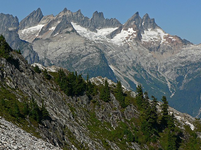
Mount Degenhardt
| Description |
Abies lasiocarpa,
Tsuga mertensiana English: Mount Terror (left skyline), Mount Degenhardt (left center skyline) with Pinnacle Peak in front, The Pyramid, Inspiration Peak (center), McMillan Spires (right center); Subalpine Fir and Mountain Hemlock (foreground) |
| Date | 14 September 2007, 15:00:28 −07:00 |
| Source | Own work |
| Author | Walter Siegmund |
| Camera location | | View this and other nearby images on: OpenStreetMap |
|
|---|
- Location Datum: WGS84
- Viewpoint location: Thornton Lakes, Trappers Peak Trail, North Cascades National Park
- Viewpoint elevation: 1719 meter (5640 ft)
- View direction: North
- Camera: Panasonic DMC-FZ5
- Exposure Time: 1/1600
- F Number: f/5.6
- Focal Length: 18.6
- Focal Length In 35mm Film: 112
- ISO Speed Rating: 80
©2007 Walter Siegmund
Licensing
I, the copyright holder of this work, hereby publish it under the following licenses:

|
Permission is granted to copy, distribute and/or modify this document under the terms of the GNU Free Documentation License, Version 1.2 or any later version published by the Free Software Foundation; with no Invariant Sections, no Front-Cover Texts, and no Back-Cover Texts. A copy of the license is included in the section entitled GNU Free Documentation License. |
| This file is licensed under the Creative Commons Attribution-Share Alike 3.0 Unported license. | ||
| ||
| This licensing tag was added to this file as part of the GFDL licensing update. |
This file is licensed under the
Creative Commons
Attribution 2.5 Generic license.
- You are free:
- to share – to copy, distribute and transmit the work
- to remix – to adapt the work
- Under the following conditions:
- attribution – You must give appropriate credit, provide a link to the license, and indicate if changes were made. You may do so in any reasonable manner, but not in any way that suggests the licensor endorses you or your use.
You may select the license of your choice.
File history
Click on a date/time to view the file as it appeared at that time.
| Date/Time | Thumbnail | Dimensions | User | Comment | |
|---|---|---|---|---|---|
| current | 18:37, 21 July 2013 |
| 2,560 × 1,920 (2.42 MB) | Wsiegmund | Adobe Photoshop Elements 11.0; 20% Auto Smart Fix, Adjust Lighting/Shadows/Highlights |
| 04:00, 6 November 2009 |
 | 2,560 × 1,920 (1.42 MB) | Wsiegmund | Photoshop Elements 4.0; autosmartfix, autocontrast, levels tools | |
| 15:54, 22 September 2007 |
 | 2,560 × 1,920 (1.89 MB) | Wsiegmund | == Summary == '''Mount Degenhardt''' {{Information |Description = {{en| Mount Degenhardt Mount Terror (left), Pinnacle Peak, The Pyramid, Inspiration Peak, McMillan Spires (right)}} |Source = Own work |Date = 2007:09:14T15:00:28-7.00 | |
File usage
The following pages on the English Wikipedia use this file (pages on other projects are not listed):
Global file usage
The following other wikis use this file:
- Usage on arz.wikipedia.org
- Usage on ceb.wikipedia.org
- Usage on cs.wikipedia.org
- Usage on de.wikipedia.org
- Usage on es.wikipedia.org
- Usage on fr.wikipedia.org
- Usage on he.wikipedia.org
- Usage on hu.wikipedia.org
- Usage on is.wikipedia.org
- Usage on it.wikipedia.org
- Usage on lld.wikipedia.org
- Usage on ur.wikipedia.org
- Usage on www.wikidata.org