
Size of this preview:
800 × 450 pixels. Other resolutions:
320 × 180 pixels |
640 × 360 pixels |
1,024 × 576 pixels |
1,280 × 720 pixels |
3,072 × 1,728 pixels.
Original file (3,072 × 1,728 pixels, file size: 690 KB, MIME type: image/jpeg)
| This is a file from the
Wikimedia Commons. Information from its
description page there is shown below. Commons is a freely licensed media file repository. You can help. |
Summary
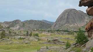
| Description | Landscape of Bayanaul with mount Bulka (Loaf) on the right known for six lakes located at the top of it |
| Date | |
| Source | Own work |
| Author | Ekamaloff |
| Camera location |
| View this and other nearby images on: OpenStreetMap |
|
|---|
Licensing
| This work has been released into the
public domain by its author, I,
Ekamaloff. This applies worldwide. In some countries this may not be legally possible; if so: I, Ekamaloff grants anyone the right to use this work for any purpose, without any conditions, unless such conditions are required by law. |
File history
Click on a date/time to view the file as it appeared at that time.
| Date/Time | Thumbnail | Dimensions | User | Comment | |
|---|---|---|---|---|---|
| current | 17:59, 18 July 2007 |
| 3,072 × 1,728 (690 KB) | Ekamaloff | {{Information |Description=Mount Bulka (Loaf) |Source=self-made |Date=July 13 2007 |Author= Ekamaloff }} {{Location|50|48|51.4|N|75|33|12.7|E}} Category:Images by Ekamaloff Category:Bayanaul |
File usage
The following pages on the English Wikipedia use this file (pages on other projects are not listed):
Global file usage
The following other wikis use this file:
- Usage on az.wikipedia.org
- Usage on bg.wikipedia.org
- Usage on en.wikivoyage.org
- Usage on es.wikipedia.org
- Usage on fa.wikipedia.org
- Usage on fr.wikipedia.org
- Usage on fr.wikivoyage.org
- Usage on hu.wikipedia.org
- Usage on it.wikipedia.org
- Usage on kk.wikipedia.org
- Usage on pl.wikipedia.org
- Usage on ru.wikipedia.org
- Usage on ru.wikivoyage.org
- Usage on sl.wikipedia.org
- Usage on tr.wikipedia.org
- Usage on uk.wikipedia.org
- Usage on www.wikidata.org
- Usage on zh.wikipedia.org
- Usage on zh.wikivoyage.org