Original file (2,992 × 2,398 pixels, file size: 5.18 MB, MIME type: image/jpeg)
| This is a file from the
Wikimedia Commons. Information from its
description page there is shown below. Commons is a freely licensed media file repository. You can help. |
Summary
| Title |
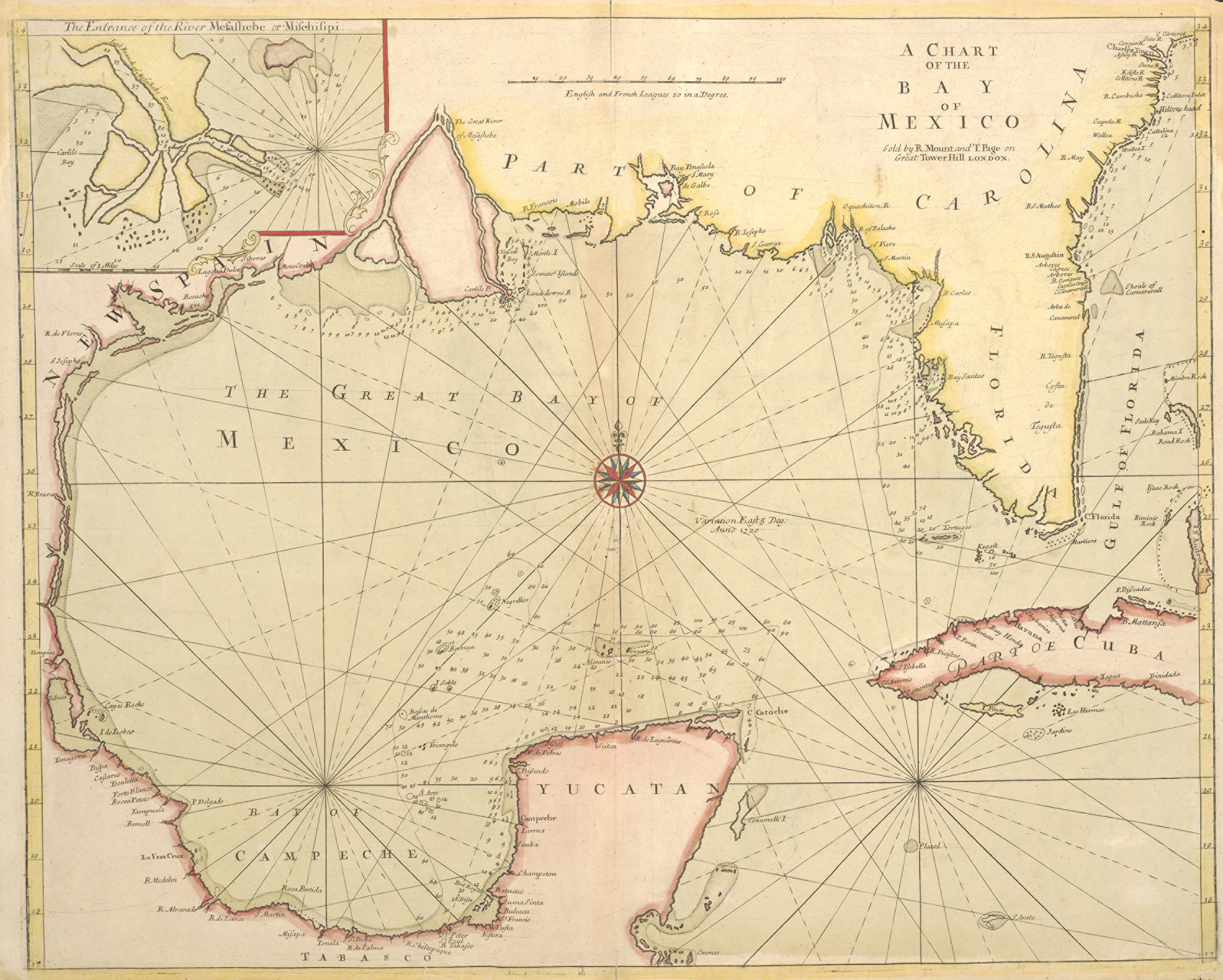
English: A Chart of the Bay of Mexico |
||||||||||||||||||||||||||
| Description |
English: Until the publication of Guillaume Delisle's famous map Carte de la Louisiane of 1718, this English sea chart was the best printed map available of the Gulf Coast and the mouth of the Mississippi. The British book, map, and chart-making and publishing firm of Mount & Page may have issued the map separately as early as 1700 since that date appears to the east of the compass rose in the center of the Gulf. Coastal mapping scholar Jack Jackson speculated that the English probably had access to a captured copy of Spanish pilots Juan Enriquez Barroto's or Juan Bisente del Campo's maps of the Gulf Coast since they reflect Bisente's coastal details and Barroto's toponyms. Jackson also believed that the inset map at upper left may be based upon information from Captain William Bond's 1699 reconnaissance voyage of the mouth of the Mississippi on behalf of Dr. Daniel Coxe's Anglo-Dutch Carolana Company. At that time Bond's ship ascended the river to a point just below New Orleans before Bienville convinced him that the French already controlled the river. Unfortunately, Bond's presumed charts are missing. Mount & Page's chart and its Gulf coast interpretation was also influential for other English chartmakers. |
||||||||||||||||||||||||||
| Date | |||||||||||||||||||||||||||
| Source | UTA Libraries Cartographic Connections: map / text | ||||||||||||||||||||||||||
| Creator |
|
||||||||||||||||||||||||||
| Credit line |
English: The University of Texas at Arlington Libraries Special Collections |
||||||||||||||||||||||||||
| Geotemporal data | |||||||||||||||||||||||||||
| Map location | Gulf of Mexico | ||||||||||||||||||||||||||
| Bibliographic data | |||||||||||||||||||||||||||
| Publication |
Atlas Novus Maritimus |
||||||||||||||||||||||||||
| Author |
|
||||||||||||||||||||||||||
| Place of publication | London | ||||||||||||||||||||||||||
| Archival data | |||||||||||||||||||||||||||
| Collection |
|
||||||||||||||||||||||||||
| Dimensions | height: 46 cm (18.1 in); width: 57.5 cm (22.6 in) | ||||||||||||||||||||||||||
| Medium | hand-colored engraving on paper | ||||||||||||||||||||||||||
| artwork-references |
Jackson, Jack Flags Along the Coast, no. 18 , pp. 46, 50–55 Hoffman, Paul E. (2003) "Discovery and Early Cartography of the Northern Gulf Coast" in Lemmon, Alfred E. , ed. Charting Louisiana: Five Hundred Years of Maps, New Orleans: The Historic New Orleans Collection, pp. 18, 35 Huseman, Ben W. (2016) Enlightenment Mapmakers and the Southwest Borderlands: Treasures from the Virginia Garrett Cartographic Library, Arlington: University of Texas at Arlington Libraries, no. 35 , p. 32 |
||||||||||||||||||||||||||
Licensing

|
This file was provided to Wikimedia Commons by the
University of Texas at Arlington Libraries as part of a
cooperation project. The University of Texas at Arlington Libraries is part of the
University of Texas at Arlington, a public research university located in Arlington, Texas.
|
|
The author died in 1733, so this work is in the public domain in its country of origin and other countries and areas where the copyright term is the author's life plus 100 years or fewer. This work is in the public domain in the United States because it was published (or registered with the U.S. Copyright Office) before January 1, 1929. | |
| This file has been identified as being free of known restrictions under copyright law, including all related and neighboring rights. | |
File history
Click on a date/time to view the file as it appeared at that time.
| Date/Time | Thumbnail | Dimensions | User | Comment | |
|---|---|---|---|---|---|
| current | 20:50, 11 May 2019 |
| 2,992 × 2,398 (5.18 MB) | Michael Barera | Higher resolution |
| 20:32, 13 April 2018 |
 | 1,131 × 914 (1.23 MB) | Texh&tc | User created page with UploadWizard |
File usage
Global file usage
The following other wikis use this file:
- Usage on ar.wikipedia.org
- Usage on es.wikipedia.org
- Usage on incubator.wikimedia.org
- Usage on tl.wikipedia.org