
Size of this preview:
650 × 599 pixels. Other resolutions:
260 × 240 pixels |
521 × 480 pixels |
652 × 601 pixels.
Original file (652 × 601 pixels, file size: 19 KB, MIME type: image/png)
| This is a file from the
Wikimedia Commons. Information from its
description page there is shown below. Commons is a freely licensed media file repository. You can help. |
Summary
| Description |
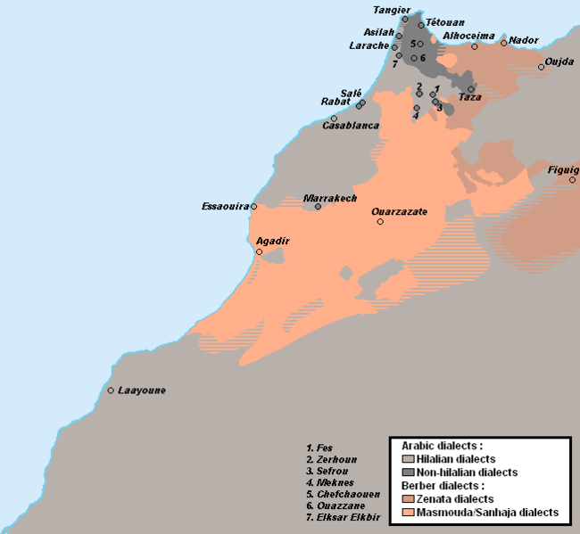
English: Linguistic map of Morocco, map drawn acc. to:
|
| Date | 18 July 2012 (original upload date) |
| Source |
Own work Own made map |
| Author | Omar-Toons |
| Other versions |
 |
Licensing
Omar-Toons at
English Wikipedia, the copyright holder of this work, hereby publishes it under the following licenses:

|
Permission is granted to copy, distribute and/or modify this document under the terms of the GNU Free Documentation License, Version 1.2 or any later version published by the Free Software Foundation; with no Invariant Sections, no Front-Cover Texts, and no Back-Cover Texts. A copy of the license is included in the section entitled GNU Free Documentation License. |
This file is licensed under the
Creative Commons
Attribution-Share Alike 3.0 Unported license.
Attribution:
Omar-Toons at
English Wikipedia
- You are free:
- to share – to copy, distribute and transmit the work
- to remix – to adapt the work
- Under the following conditions:
- attribution – You must give appropriate credit, provide a link to the license, and indicate if changes were made. You may do so in any reasonable manner, but not in any way that suggests the licensor endorses you or your use.
- share alike – If you remix, transform, or build upon the material, you must distribute your contributions under the same or compatible license as the original.
You may select the license of your choice.
Original upload log
Transferred from en.wikipedia to Commons by Omar-toons using CommonsHelper.
The original description page was
here. All following user names refer to en.wikipedia.
- 2012-07-19 17:19 Omar-Toons 652×601× (22351 bytes) Uploading a self-made file using [[Wikipedia:File_Upload_Wizard|File Upload Wizard]]
File history
Click on a date/time to view the file as it appeared at that time.
| Date/Time | Thumbnail | Dimensions | User | Comment | |
|---|---|---|---|---|---|
| current | 09:19, 10 December 2019 |
| 652 × 601 (19 KB) | Omar-toons | Mod. Arabic-speaking areas Bhalil + Fechtala + More precise limits for Warayn & Seghrouchen |
| 04:12, 20 November 2013 |
 | 652 × 601 (22 KB) | Omar-toons | Corr. Essaouira's location | |
| 03:32, 15 December 2012 |
 | 652 × 601 (22 KB) | Omar-toons | {{Information |Description={{en|Linguistic map of Morocco}} |Source= Own made map |Date={{Original upload date|2012-07-18}}<br/> ({{Original upload date|2012-07-19}}) |Author= Omar-Toons. Original uploader was {{user at project|O... |
File usage
The following pages on the English Wikipedia use this file (pages on other projects are not listed):
Global file usage
The following other wikis use this file:
- Usage on ar.wikipedia.org
- Usage on ary.wikipedia.org
- Usage on arz.wikipedia.org
- Usage on ca.wikipedia.org
- Usage on da.wikipedia.org
- Usage on es.wikipedia.org
- Usage on fr.wikipedia.org
- Usage on io.wikipedia.org
- Usage on it.wikipedia.org
- Usage on mt.wikipedia.org
- Usage on nl.wikipedia.org
- Usage on no.wikipedia.org
- Usage on shi.wikipedia.org
- Usage on simple.wikipedia.org
- Usage on si.wikipedia.org
- Usage on tr.wikipedia.org
- Usage on tum.wikipedia.org