No higher resolution available.
MonthlyMeanT.gif (550 × 340 pixels, file size: 405 KB, MIME type: image/gif, looped, 12 frames, 11 s)
| This is a file from the
Wikimedia Commons. Information from its
description page there is shown below. Commons is a freely licensed media file repository. You can help. |
Summary
| Description |
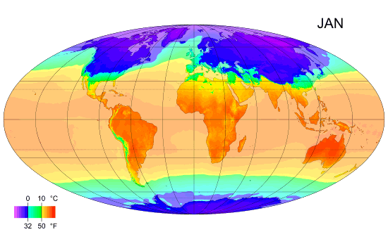
English: Animated global map of monthly long term mean surface air temperature (Mollweide projection). |
| Date | |
| Source | Own work by uploader, sources: CRU CL 2.0 (New, M., Lister, D., Hulme, M. and Makin, I., 2002: A high-resolution data set of surface climate over global land areas. Climate Research 21: 1–25), NCEP/NCAR Reanalysis Derived data v. 1 provided by the NOAA/OAR/ESRL PSD, Boulder, CO (Kalnay et al., 1996: The NCEP/NCAR 40-Year Reanalysis Project. Bulletin of the American Meteorological Society 77 (3): 437–471.), World Coast Line. |
| Author | PZmaps |
| Other versions | Derivative works of this file: MonthlyMeanT DEC.jpg |
Licensing
I, the copyright holder of this work, hereby publish it under the following licenses:
This file is licensed under the
Creative Commons
Attribution-Share Alike 3.0 Unported license.
- You are free:
- to share – to copy, distribute and transmit the work
- to remix – to adapt the work
- Under the following conditions:
- attribution – You must give appropriate credit, provide a link to the license, and indicate if changes were made. You may do so in any reasonable manner, but not in any way that suggests the licensor endorses you or your use.
- share alike – If you remix, transform, or build upon the material, you must distribute your contributions under the same or compatible license as the original.

|
Permission is granted to copy, distribute and/or modify this document under the terms of the GNU Free Documentation License, Version 1.2 or any later version published by the Free Software Foundation; with no Invariant Sections, no Front-Cover Texts, and no Back-Cover Texts. A copy of the license is included in the section entitled GNU Free Documentation License. |
You may select the license of your choice.
File history
Click on a date/time to view the file as it appeared at that time.
| Date/Time | Thumbnail | Dimensions | User | Comment | |
|---|---|---|---|---|---|
| current | 12:38, 25 February 2009 |
| 550 × 340 (405 KB) | PZmaps | {{Information |Description={{en|1=Global animated map of monthly long term mean surface air temperature (Mollweide projection).}} |Source=Own work by uploader, sources: [http://www.cru.uea.ac.uk/cru/data/hrg.htm CRU CL 2.0] (New, M., Lister, D., Hulme, M. |
File usage
The following pages on the English Wikipedia use this file (pages on other projects are not listed):
Global file usage
The following other wikis use this file:
- Usage on am.wikipedia.org
- Usage on ar.wikipedia.org
- Usage on ast.wikipedia.org
- Usage on azb.wikipedia.org
- Usage on az.wikipedia.org
- Usage on ba.wikipedia.org
- Usage on bg.wikipedia.org
- Usage on bo.wikipedia.org
- Usage on ca.wikipedia.org
- Usage on ceb.wikipedia.org
- Usage on ce.wikipedia.org
- Usage on ckb.wikipedia.org
- Usage on cy.wikipedia.org
- Usage on de.wikipedia.org
- Usage on en.wikibooks.org
- Usage on en.wikiversity.org
- Usage on es.wikipedia.org
- Usage on es.wikinews.org
- Usage on fi.wikipedia.org
- Usage on hu.wikipedia.org
- Usage on hy.wikipedia.org
- Usage on hy.wiktionary.org
- Usage on id.wikipedia.org
- Usage on ig.wikipedia.org
- Usage on ilo.wikipedia.org
- Usage on incubator.wikimedia.org
View more global usage of this file.