
Size of this JPG preview of this TIF file:
477 × 600 pixels. Other resolutions:
191 × 240 pixels |
382 × 480 pixels |
611 × 768 pixels |
1,024 × 1,287 pixels.
Original file (1,024 × 1,287 pixels, file size: 3.77 MB, MIME type: image/tiff)
| This is a file from the
Wikimedia Commons. Information from its
description page there is shown below. Commons is a freely licensed media file repository. You can help. |
Summary
| Description |
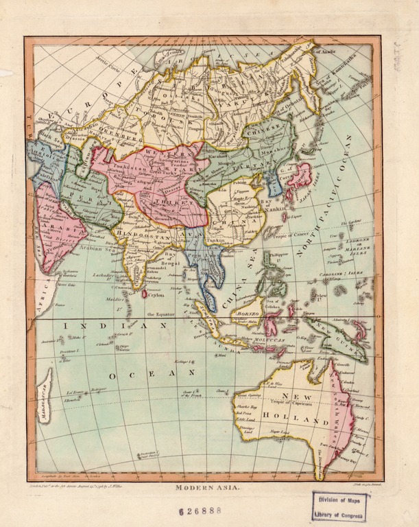
English: John Wilkes was a London publisher best known for his Encyclopaedia Londinensis; or, universal dictionary of arts, sciences, and literature (1801-28). Wilkes frequently worked with Samuel John Neele, the engraver of this hand-colored map of “modern Asia.” The map reflects late 18th-century European geographic conceptions and terminology. India is referred to as “Hindoostan,” while much of the interior is shown as comprised of “Western Tartary” and “Chinese Tartary.” “Tartary” was a designation applied by Europeans to those parts of Asia inhabited by nomadic Turkic and Mongol peoples. This map shows Tartary as stretching from the Caspian Sea to the Pacific Ocean. فارسی: نقشهٔ «آسیای نوین». این نقشه اطلاحات رایج و تصورات جغرافیدانان اروپایی اواخر سدهٔ هجدهم میلادی را نشان میدهد. العربية: كان جون ويلكس ناشرا لندنيا واشتهر لعمله موسوعة لوندينينسيس؛ أو القاموس ألعالمي للفنون والعلوم والأدب (١٨٠١-٢٨). عمل ويلكس دائما مع سامويل جون نيل وهو نقاش هذه الخريطة الملونة باليد "لآسيا الحديثة". تعكس الخريطة المفاهيم الجغرافية والمصطلحات بأوروبافي أواخر القرن الثامن عشر. يشار إلى الهند "بهندوستان" بينما يعرض الكثير من الداخل كأنه مؤلف من "تارتاري الغربية" و"تارتاري الصينية". "تارتارى" هي التسمية التي أطلقها الأوربيون على تلك المناطق من آسيا التي يسكنها شعوب المنغولية والتركية. تبين هذه الخريطة تارتاري ممتدة من بحر قزوين إلى المحيط الهادئ. Español: John Wilkes fue un editor de Londres conocido por su Enciclopaedia Londinensis, o diccionario universal de las artes, las ciencias y la literatura (1801-28). Wilkes solía trabajar con John Samuel Neele, el grabador de este mapa pintado a mano de "Asia moderna". El mapa refleja la terminología yconcepciones geográficas europeas de finales del siglo XVIII. Se hace referencia a la India como "Hindoostan", mientras que una gran parte del interior se muestra como compuesta de "Tartaria Occidental" y "Tartaria China". "Tartaria" fue una denominación que aplicaron los europeos a las partes de Asia habitadas por los pueblos nómades turcos y mongoles. Este mapa muestra la Tartaria que se extiende desde el Mar Caspio hasta el Océano Pacífico. Français : John Wilkes était un éditeur de Londres surtout connu pour son Encyclopaedia Londinensis, ou dictionnaire universel des arts, des sciences et de la littérature (1801-1828). Wilkes travaillait souvent avec Samuel John Neele, le graveur de cette cette carte coloriée à la main de “l'Asie moderne“. La carte reflèteles conceptions et la terminologie géographiques européennes de la fin du 18ème siècle. L'Inde est appelée “Hindoustan“, tandis que la plus grande partie du continent asiatique est présentée comme constituée de la “Tartarie Occidentale“ et de la “Tartarie Chinoise“. “Tartarie“ était le nom donné par les Européens à ces régions d'Asie habitées par des populations nomades turciques et mongoles. Sur cette carte, la Tartarie s'étire de la mer Caspienne jusqu'à l'océan Pacifique. Português: John Wilkes foi um editor em Londres conhecido pela sua Enciclopédia Londinensis; ou dicionário universal de artes, ciências e literatura (1801-28). Wilkes trabalhou muitas vezes com John Samuel Neele, o gravador deste mapa colorido a mão da "Ásia moderna." O mapa reflete final do 18 th- conceitos geográficos e terminologias do.final do século Europeu. A Índia é referida como "Hindoostan," enquanto grande parte do interior é mostrado como composto de "Western Tartary" e "Chinese Tartary." "Tartary" foi uma designação empregada pelos Europeus para as partes da Ásia habitadas por povos nómades Turcos e Mongóis. Este mapa mostra Tartary como uma faixa que se extende do mar Cáspio até o Oceano Pacífico. Русский: Джон Уилкс был лондонским издаталем, наиболее известным своей работой Encyclopaedia Londinensis, или универсальным словарем искусств, наук и литературы (1801-1828 гг.). Уилкс часто работал с Самуэлем Джоном Нилом, создателем данной карты-гравюры ручной раскраски под названием "современная Азия". Карта отражает европейские географические концепции и терминологию конца XVIII века. Индия названа "Хиндустаном", а большая часть внутренней территории представлена как "Западная Тартария" и "Китайская Тартария". Тартарией европейцы называли те части Азии, которые населяли кочевые тюркские и монгольские народы. На этой карте Тартерия изображена простирающейся от Каспийского моря до Тихого океана. 中文(简体):约翰·威尔克斯是一名伦敦出版商,其代表作有 《伦敦百科全书》,或者称为《艺术、科学与文学的通用词典》 (1801-28 年)。威尔克常与“现代亚洲”手绘地图的雕刻师塞缪尔·约翰·尼乐共事。 本地图体现了 18 世纪晚期 欧洲地理概念与术语。 印度被称为“印度斯坦”,其内陆大部分描述由“西方鞑靼”与“中属鞑靼”组成。 “鞑靼”是欧洲人对居住在亚洲的游牧突厥和蒙古人的称呼。 这幅地图描述的鞑靼从里海一直延伸到太平洋。 |
| Date | |
| Source | http://www.wdl.org/en/item/154/ |
| Author | Wilkes of Milland House, Sussex, John |
| Other versions |

Physical Description: 1 hand colored engraved map; 24 x 19 centimeters
Scale: 1:60,000,000
Institution: Library of Congress
Licensing
|
This work is in the public domain in its country of origin and other countries and areas where the copyright term is the author's life plus 100 years or fewer. | |
| This file has been identified as being free of known restrictions under copyright law, including all related and neighboring rights. | |
File history
Click on a date/time to view the file as it appeared at that time.
| Date/Time | Thumbnail | Dimensions | User | Comment | |
|---|---|---|---|---|---|
| current | 06:58, 16 September 2011 |
 | 1,024 × 1,287 (3.77 MB) | ZxxZxxZ |
File usage
The following pages on the English Wikipedia use this file (pages on other projects are not listed):
Global file usage
The following other wikis use this file:
- Usage on ar.wikipedia.org
- Usage on bn.wikipedia.org
- Usage on ca.wikipedia.org
- Usage on cbk-zam.wikipedia.org
- Usage on cs.wikipedia.org
- Usage on el.wikipedia.org
- Usage on es.wikipedia.org
- Usage on fa.wikipedia.org
- Usage on hy.wikipedia.org
- Usage on id.wikipedia.org
- Usage on it.wikipedia.org
- Usage on ko.wikipedia.org
- Usage on mk.wikipedia.org
- Usage on ms.wikipedia.org
- Usage on pnb.wikipedia.org
- Usage on si.wikipedia.org
- Usage on sq.wikipedia.org
- Usage on sr.wikipedia.org
- Usage on ta.wikipedia.org
- Usage on th.wikipedia.org
- Usage on ur.wikipedia.org
- Usage on zh.wikipedia.org