
Original file (11,686 × 8,255 pixels, file size: 96.59 MB, MIME type: image/jpeg)
| This is a file from the
Wikimedia Commons. Information from its
description page there is shown below. Commons is a freely licensed media file repository. You can help. |
|
| This is a featured picture, which means that members of the community have identified it as one of the finest images on the English Wikipedia, adding significantly to its accompanying article. If you have a different image of similar quality, be sure to upload it using the proper free license tag, add it to a relevant article, and nominate it. |
|
| This image was selected as picture of the day on the English Wikipedia for July 24, 2011. |
Warning: full sized image has 97MB filesize.
| Warning | The original file is very high-resolution. It might not load properly or could cause your browser to freeze when opened at full size. |
|---|
Summary
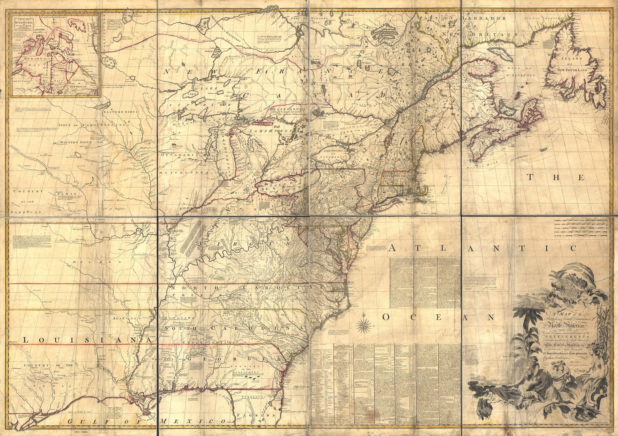
| Description | Mitchell Map - A map of the British and French dominions in North America,...; 1757 |
| Date | between 1755 and 1757 |
| Source | Library of Congress |
| Author | John Mitchell; digital version, Library of Congress, Geography and Map Division. |
| Permission ( Reusing this file) |
"The Library of Congress is providing access to these materials for educational and research purposes and is not aware of any U.S. copyright protection" (source: http://memory.loc.gov/cgi-bin/ammemrr.pl?title=Map%20Collections&coll=gmd&div=&agg=g3300&default=ammem&dir=ammem) |
| Other versions | Mitchell Map-06full2 compressed.jpg (compressed to 19 MB) |
|
Licensing
|
This work is in the public domain in its country of origin and other countries and areas where the copyright term is the author's life plus 100 years or fewer. | |
| This file has been identified as being free of known restrictions under copyright law, including all related and neighboring rights. | |
Transcription
The first part of the text between "Atlantic" and "Ocean" reads:
After the first drawing of this map in 1750, it was again corrected and improved, before it was published, and I have since taken Care to procure & examine all the information I could get, in order to render it as correct & usefull as possible; which has given occasion to this Second Edition of it, in which I have likewise inserted all the Observations I believe we have for the Geography of N. America, since I find them grossly misrepresented by others.
The Foundation of this Map is the several Manuscript Maps, Charts & Surveys that have been lately made of our Colonies, which represent most Places from the Ocean to the Missisipi. But in order to know the true Situation of those Places, we must have their Latitudes & Longitudes, which are of more Consequence in a general Map, than their bare Shape or Figure, which we only find represented in our Draughts & Surveys. But after having consulted all the Observations I believe that we have, I found the true Situation, or Latitude & Longitude, of many Places was undetermined or uncertain; & that we had no Accounts of them, but what might be found in the Journals of our Ships of War kept in the Admiralty Office; which I had Recourse to for that reason, and have extracted from them whatever relates to our purposem which are the chief Source of the Corrections & observations here inserted.
Since the Publication of this Map likewise I have examined & compared with other Accounts, the Observations of Mr. Chabert; which were not made when our Map was first drawn, nor known in England till after it was published; so that we neither followed nor rejected them. From these Authorities we find but two Alteration necessary in our Map: 1. In the Latitude of Cape Race: 2. In the Longitude of Cape Sable. I. Cape Race was laid down in Lat. 46°.55', from the Surveys of Capt. Gaudy & Durell, who make it in Lat 47°.2', & 46°.57'; and the Observations of Bellin, which make it in 46°.50'. But by all the accounts in our Ships of War, confirmed by those of Chabert, it is in Lat 46°.30', or 35' at most; from which, and other Observations here inserted, we have corrected that and other parts of Newfoundland.
In the longitude of Cape Race, different Reckonings in our Ships from Cape Breton, Canso, & Boston, differ 2 Degrees (on Account of the Currents), and more than Reckonings from Europe.
File history
Click on a date/time to view the file as it appeared at that time.
| Date/Time | Thumbnail | Dimensions | User | Comment | |
|---|---|---|---|---|---|
| current | 22:35, 11 December 2009 |
| 11,686 × 8,255 (96.59 MB) | Kaldari | higher resolution |
| 07:39, 19 October 2006 |
 | 2,400 × 1,696 (1.23 MB) | Pfly | {{Information |Description= Mitchell Map - A map of the British and French dominions in North America,...; 1757 |Source= http://hdl.loc.gov/loc.gmd/g3300.ar004000 |Date= 1755-1757 |Author= John Mitchell; digital version, Library of Congress, Geography and |
File usage
- Isle Phelipeaux
- John Martin Mack
- John Mitchell (geographer)
- Kittanning (village)
- Kuskusky
- Logstown
- Lower Shawneetown
- Mitchell Map
- Muskingum (village)
- Pickawillany
- Saucunk
- Shamokin (village)
- Shannopin's Town
- Westo
- Talk:Mitchell Map
- User talk:Kaldari/Archive 10
- User talk:Kaldari/Archive 8
- Wikipedia:Featured picture candidates/December-2009
- Wikipedia:Featured picture candidates/Mitchell Map
- Wikipedia:Featured pictures/Diagrams, drawings, and maps/Maps
- Wikipedia:Featured pictures thumbs/21
- Wikipedia:Main Page history/2011 July 24
- Wikipedia:Picture of the day/July 2011
- Wikipedia:WikiProject United States/Featured pictures
- Wikipedia:WikiProject United States/Quality content
- Wikipedia:WikiProject United States/Recognized content
- Wikipedia:WikiProject United States Government
- Wikipedia:WikiProject United States Government/Featured Content
- Wikipedia:Wikipedia Signpost/2010-01-04/Features and admins
- Wikipedia:Wikipedia Signpost/2010-01-11/Features and admins
- Wikipedia:Wikipedia Signpost/Single/2010-01-04
- Wikipedia:Wikipedia Signpost/Single/2010-01-11
- Template:POTD/2011-07-24
- Portal:Geography/Selected picture
Global file usage
The following other wikis use this file:
- Usage on da.wikipedia.org
- Usage on de.wikipedia.org
- Usage on fr.wikipedia.org
- Usage on he.wikipedia.org
- Usage on it.wikipedia.org
- Usage on nl.wikipedia.org
- Usage on pt.wikipedia.org
- Usage on ru.wikipedia.org
- Usage on sh.wikipedia.org
- Usage on uk.wikipedia.org
- Usage on www.wikidata.org