
Size of this preview:
800 × 575 pixels. Other resolutions:
320 × 230 pixels |
640 × 460 pixels |
1,024 × 736 pixels |
1,280 × 920 pixels |
1,496 × 1,075 pixels.
Original file (1,496 × 1,075 pixels, file size: 2.63 MB, MIME type: image/png)
| This is a file from the
Wikimedia Commons. Information from its
description page there is shown below. Commons is a freely licensed media file repository. You can help. |
Summary
| Description |
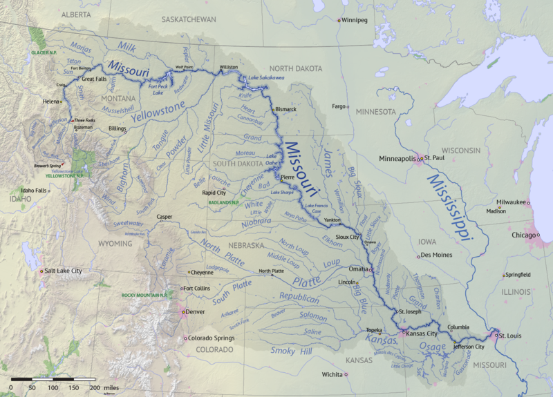
English: Map of the Missouri River drainage basin in the US and Canada. made using USGS and Natural Earth data. Replacement for
File:Missouririvermap.jpg. |
| Date | |
| Source | Own work |
| Author | Shannon1 |
.png)
Licensing
I, the copyright holder of this work, hereby publish it under the following licenses:

|
Permission is granted to copy, distribute and/or modify this document under the terms of the GNU Free Documentation License, Version 1.2 or any later version published by the Free Software Foundation; with no Invariant Sections, no Front-Cover Texts, and no Back-Cover Texts. A copy of the license is included in the section entitled GNU Free Documentation License. |
This file is licensed under the
Creative Commons Attribution-Share Alike
4.0 International,
3.0 Unported,
2.5 Generic,
2.0 Generic and
1.0 Generic license.
- You are free:
- to share – to copy, distribute and transmit the work
- to remix – to adapt the work
- Under the following conditions:
- attribution – You must give appropriate credit, provide a link to the license, and indicate if changes were made. You may do so in any reasonable manner, but not in any way that suggests the licensor endorses you or your use.
- share alike – If you remix, transform, or build upon the material, you must distribute your contributions under the same or compatible license as the original.
You may select the license of your choice.
File history
Click on a date/time to view the file as it appeared at that time.
| Date/Time | Thumbnail | Dimensions | User | Comment | |
|---|---|---|---|---|---|
| current | 00:15, 9 April 2018 |
| 1,496 × 1,075 (2.63 MB) | Shannon1 | missing label |
| 21:56, 30 March 2018 |
 | 1,500 × 1,080 (2.8 MB) | Shannon1 | slight fixes | |
| 19:30, 30 March 2018 |
 | 1,500 × 1,078 (2.78 MB) | Shannon1 | {{Information |description ={{en|1=Map of the Missouri River drainage basin in the US and Canada. made using USGS and Natural Earth data. Replacement for File:Missouririvermap.jpg.}} |source =Own work |author = Shannon1 |date =2018-03-21 }} Category:Missouri River |
File usage
The following pages on the English Wikipedia use this file (pages on other projects are not listed):
- Emilie (steamboat)
- Grand River (South Dakota)
- Joseph LaBarge
- List of dams in the Missouri River watershed
- List of longest rivers of the United States (by main stem)
- List of tributaries of the Missouri River
- Missouri River
- Spread Eagle (steamboat)
- Yellowstone expedition
- User:Shannon1/Maps
- User:Shannon1/Maps/to-do
- User:Shannon1/Sandbox 5
- Wikipedia:Graphics Lab/Map workshop/Archive/Jul 2011
Global file usage
The following other wikis use this file:
- Usage on af.wikipedia.org
- Usage on azb.wikipedia.org
- Usage on az.wiktionary.org
- Usage on ba.wikipedia.org
- Usage on be.wikipedia.org
- Usage on bh.wikipedia.org
- Usage on bn.wikipedia.org
- Usage on ca.wikipedia.org
- Usage on cv.wikipedia.org
- Usage on da.wikipedia.org
- Usage on es.wikipedia.org
- Iowa
- Dakota del Norte
- Dakota del Sur
- Denver
- Río Misuri
- Bismarck (Dakota del Norte)
- Misuri
- Río Yellowstone
- Lincoln (Nebraska)
- Omaha (Nebraska)
- Columbia (Misuri)
- Kansas City (Misuri)
- Topeka
- Río Marías
- Kansas City (Kansas)
- Río Cheyenne
- Río Gallatin
- Great Falls (Montana)
- Río Platte
- Río Milk
- Río James (Dakotas)
- Río Smoky Hill
- Río Saline (Kansas)
- Río Niobrara
- Río Pequeño Misuri
- Río Bighorn
- Río Madison
- Río Musselshell
- Río Powder
- Río Tongue
- Río Osage
- Río Jefferson
- Río Judith
- Casper (Wyoming)
- Fort Collins (Colorado)
- Presa y lago Oahe
- Rapid City (Dakota del Sur)
View more global usage of this file.