
Size of this preview:
800 × 447 pixels. Other resolutions:
320 × 179 pixels |
640 × 358 pixels |
1,024 × 572 pixels |
1,542 × 862 pixels.
Original file (1,542 × 862 pixels, file size: 265 KB, MIME type: image/png)
| This is a file from the
Wikimedia Commons. Information from its
description page there is shown below. Commons is a freely licensed media file repository. You can help. |
Summary
| Description |
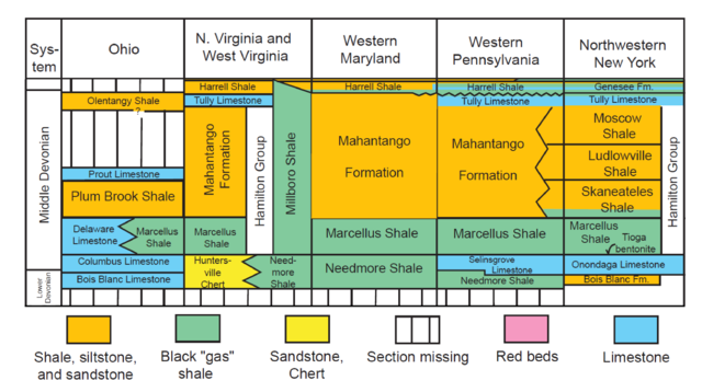
English: Table 2 of Report 2006 1237 cropped to show only the Middle to uppermost Lower Devonian |
| Date | |
| Source | [1] Table 2 of USGS Report 2006 1237 |
| Author | USGS |
Licensing
This image is in the
public domain in the United States because it only contains materials that originally came from the
United States Geological Survey, an agency of the
United States Department of the Interior. For more information, see
the official USGS copyright policy.
|
File history
Click on a date/time to view the file as it appeared at that time.
| Date/Time | Thumbnail | Dimensions | User | Comment | |
|---|---|---|---|---|---|
| current | 18:36, 5 May 2014 |
| 1,542 × 862 (265 KB) | Mikenorton | User created page with UploadWizard |
File usage
The following pages on the English Wikipedia use this file (pages on other projects are not listed):