
Size of this PNG preview of this SVG file:
800 × 476 pixels. Other resolutions:
320 × 191 pixels |
640 × 381 pixels |
1,024 × 610 pixels |
1,280 × 762 pixels |
2,560 × 1,524 pixels |
1,389 × 827 pixels.
Original file (SVG file, nominally 1,389 × 827 pixels, file size: 43 KB)
| This is a file from the
Wikimedia Commons. Information from its
description page there is shown below. Commons is a freely licensed media file repository. You can help. |
Summary
| Description |
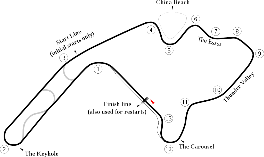
English: Track map of
Mid-Ohio Sports Car Course. |
| Date | |
| Source | Own work |
| Author | Will Pittenger |
| Other versions |
 |
| Camera location |
| View this and other nearby images on: OpenStreetMap |
|
|---|
Licensing
| I, the copyright holder of this work, release this work into the
public domain. This applies worldwide. In some countries this may not be legally possible; if so: I grant anyone the right to use this work for any purpose, without any conditions, unless such conditions are required by law. |
File history
Click on a date/time to view the file as it appeared at that time.
| Date/Time | Thumbnail | Dimensions | User | Comment | |
|---|---|---|---|---|---|
| current | 23:25, 18 October 2009 |
| 1,389 × 827 (43 KB) | Spyder Monkey | bypassed keyhole chicane |
| 07:27, 30 June 2008 |
 | 1,389 × 827 (43 KB) | Will Pittenger | New version that adds circle around Turn 1. | |
| 07:13, 30 June 2008 |
 | 1,389 × 827 (42 KB) | Will Pittenger | {{Information |Description={{en|1=Track map of w:Mid-Ohio Sports Car Course.}} |Source=Own work by uploader |Author= Will Pittenger |Date=6-30-2008 |Permission= |other_versions=[[:Image:Mid-Ohio.png|PNG version for those with b |
File usage
The following pages on the English Wikipedia use this file (pages on other projects are not listed):
- 1998 Miller Lite 200
- 1999 Miller Lite 200
- 2001 Grand Prix of Mid-Ohio
- 2001 Miller Lite 200
- 2002 American Le Mans at Mid-Ohio
- 2002 CART Grand Prix of Mid-Ohio
- 2003 Champ Car Grand Prix of Mid-Ohio
- 2004 American Le Mans at Mid-Ohio
- 2005 American Le Mans at Mid-Ohio
- 2006 American Le Mans at Mid-Ohio
- 2007 Honda 200
- 2007 Sports Car Challenge of Mid-Ohio
- 2008 Honda 200
- 2008 Sports Car Challenge of Mid-Ohio
- 2009 EMCO Gears Classic
- 2009 Sports Car Challenge of Mid-Ohio
- 2010 Mid-Ohio Sports Car Challenge
- 2011 Mid-Ohio Sports Car Challenge
- 2012 Mid-Ohio Sports Car Challenge
- 2013 Nationwide Children's Hospital 200
- 2014 Honda Indy 200 at Mid-Ohio
- 2016 Honda Indy 200
- 2017 Honda Indy 200
- 2017 Mid-Ohio Challenge
- 2018 Honda Indy 200
- 2018 Rock N Roll Tequila 170
- 2018 Sports Car Challenge of Mid-Ohio
- 2019 B&L Transport 170
- 2019 Honda Indy 200
- 2019 Sports Car Challenge of Mid-Ohio
- 2020 Acura Sports Car Challenge at Mid-Ohio
- 2021 B&L Transport 170
- 2021 Dawn 150
- 2021 Honda Indy 200
- 2021 Sports Car Challenge at Mid-Ohio
- 2022 Dawn 150
- 2022 Honda Indy 200
- 2022 Lexus Grand Prix at Mid-Ohio
- 2022 O'Reilly Auto Parts 150 at Mid-Ohio
- 2023 Honda Indy 200
- 2023 O'Reilly Auto Parts 150 at Mid-Ohio
- 2023 Zinsser SmartCoat 150
- B&L Transport 170
- Flag to Flag
- Indy 200 at Mid-Ohio
- List of AMA Superbike Championship circuits
- List of American Le Mans Series circuits
- List of Can-Am Challenge Cup circuits
- List of Champ Car circuits
- List of GT World Challenge America circuits
- List of IMSA GT Championship circuits
- List of IMSA SportsCar Championship circuits
- List of NASCAR tracks
- Mid-Ohio Sports Car Course
- O'Reilly Auto Parts 150 at Mid-Ohio
- Sports Car Challenge at Mid-Ohio
- Zinsser SmartCoat 150
- User:PAUL5150/High plains raceway
Global file usage
The following other wikis use this file:
- Usage on de.wikipedia.org
- Usage on es.wikipedia.org
- Usage on fi.wikipedia.org
- Usage on fr.wikipedia.org
- Usage on hu.wikipedia.org
- 2016-os Honda Indy 200
- 2019-es IndyCar Series szezon
- 2020-as IndyCar Series szezon
- 2019-es amerikai ralikrosszbajnokság
- 2015-ös Indy Lights-szezon
- 2019-es Indy Lights-szezon
- 2016-os Indy Lights-szezon
- 2017-es Indy Lights-szezon
- 2018-as Indy Lights-szezon
- 2014-es Indy Lights-szezon
- 2013-as Indy Lights-szezon
- 2020-as Indy Lights-szezon
- 2020-as Formula Regionális Amerika-bajnokság
- 2021-es IndyCar Series szezon
- 2021-es Formula Regionális Amerika-bajnokság
- 2022-es Formula Regionális Amerika-bajnokság
- 2023-as Formula Regionális Amerika-bajnokság
- 2024-es Formula Regionális Amerika-bajnokság
- Usage on id.wikipedia.org
- Usage on it.wikipedia.org
- Usage on ja.wikipedia.org
- Usage on nl.wikipedia.org
- Usage on pt.wikipedia.org
View more global usage of this file.