Size of this preview:
800 × 497 pixels. Other resolutions:
320 × 199 pixels |
640 × 398 pixels |
1,006 × 625 pixels.
Original file (1,006 × 625 pixels, file size: 374 KB, MIME type: image/jpeg)
| This is a file from the
Wikimedia Commons. Information from its
description page there is shown below. Commons is a freely licensed media file repository. You can help. |
| Description |
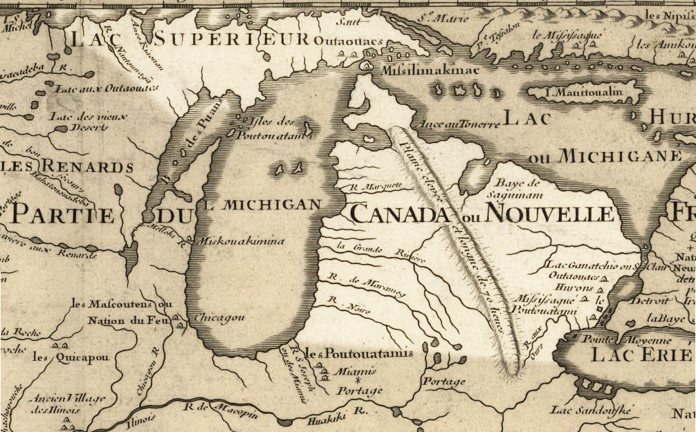
English:
Michigan 1718, approximate modern state area highlighted, from Carte de la Louisiane et du cours du Mississipi by
Guillaume de L'Isle. LicensingMy contributions cleaning and highlighting are also donated to Public Domain. Bill Whittaker ( talk) 20:14, 27 July 2009 (UTC) |
|||||||||||||||||||||||
| Date | (mod. 2009) | |||||||||||||||||||||||
| Source | Library of Congress Public Domain Site: http://hdl.loc.gov/loc.gmd/g3700.ct000666 | |||||||||||||||||||||||
| Author |
|
|||||||||||||||||||||||
| Permission ( Reusing this file) |
US Govt Public Domain, also author +100 years | |||||||||||||||||||||||

Licensing
|
This work is in the public domain in its country of origin and other countries and areas where the copyright term is the author's life plus 100 years or fewer. | |
| This file has been identified as being free of known restrictions under copyright law, including all related and neighboring rights. | |
Original upload log
The original description page was
here. All following user names refer to en.wikipedia.
- 2009-07-27 20:12 Billwhittaker 1006×625× (383135 bytes) {{Information |Description = [[Michigan]] 1718, approximate modern state area highlighted, from ''Carte de la Louisiane et du cours du Mississipi'' by [[Guillaume de L'Isle]]. |Source = Library of Congress Public Domain Site: http://hdl.loc.g
File history
Click on a date/time to view the file as it appeared at that time.
| Date/Time | Thumbnail | Dimensions | User | Comment | |
|---|---|---|---|---|---|
| current | 19:44, 21 September 2009 |
| 1,006 × 625 (374 KB) | Jeangagnon | {{Information |Description={{en| en:Michigan 1718, approximate modern state area highlighted, from ''Carte de la Louisiane et du cours du Mississipi'' by en:Guillaume de L'Isle.<br/> == Licensing: == My contributions cleaning and highlighting a |
File usage
The following pages on the English Wikipedia use this file (pages on other projects are not listed):
Global file usage
The following other wikis use this file:
- Usage on arz.wikipedia.org
- Usage on de.wikipedia.org
- Usage on es.wikipedia.org
- Usage on fr.wikipedia.org
- Michigan
- Détroit (Michigan)
- Lac Sainte-Claire
- Lac Érié
- Pierre-François-Xavier de Charlevoix
- Mascoutins
- Potéouatamis
- Pays-d'en-Haut
- Fort Michillimakinac
- Mesquakies
- Rivière Grande (Michigan)
- Fox River (Wisconsin)
- Claude Aveneau
- Lac Vieux Désert
- Henri Nouvel
- Mission Sainte-Marie
- Jean Enjalran
- Baie de Green Bay
- Lac Macatawa
- Rivière Macatawa
- Histoire du Michigan
- Jacques Testard de Montigny
- Utilisateur:Yvon Savoie/Brouillon/Charlevoix
- Usage on hsb.wikipedia.org
- Usage on incubator.wikimedia.org
- Usage on it.wikipedia.org
- Usage on ja.wikipedia.org
- Usage on ko.wikipedia.org
- Usage on no.wikipedia.org
- Usage on pt.wikipedia.org
- Usage on sr.wikipedia.org
- Usage on tr.wikipedia.org
- Usage on www.wikidata.org